fbpx
Wikipedia

Interstate 90

Interstate 90 (I-90) is an east–west transcontinental freeway and the longest Interstate Highway in the United States at 3,021 miles (4,862 km). It begins in Seattle, Washington, and travels through the Pacific Northwest, Mountain West, Great Plains, Midwest, and the Northeast, ending in Boston, Massachusetts. The highway serves 13 states and has 15 auxiliary routes, primarily in major cities such as Chicago, Cleveland, Buffalo, and Rochester.

Interstate 90

Map of the contiguous United States with I-90 highlighted in red
Route information
Length3,021.22 mi[1] (4,862.18 km)
Existed1956–present
NHSEntire route
Major junctions
West end SR 519 in Seattle, WA
Major intersections
East end Route 1A/Logan International Airport in Boston, MA
Location
CountryUnited States
StatesWashington, Idaho, Montana, Wyoming, South Dakota, Minnesota, Wisconsin, Illinois, Indiana, Ohio, Pennsylvania, New York, Massachusetts
Highway system

I-90 begins at Washington State Route 519 in Seattle and crosses the Cascade Range in Washington and the Rocky Mountains in Montana. It then traverses the northern Great Plains and travels southeast through Wisconsin and the Chicago area by following the southern shore of Lake Michigan. The freeway continues across Indiana and follows the shore of Lake Erie through Ohio and Pennsylvania to Buffalo. I-90 travels across New York by roughly following the historic Erie Canal and traverses Massachusetts, reaching its eastern terminus at Massachusetts Route 1A near Logan International Airport in Boston.

The freeway was established by the Federal-Aid Highway Act of 1956, replacing a series of existing U.S. highways that had been preceded by local roads and auto trails established in the early 20th century. I-90 was numbered in 1957, reflecting its status as the northernmost transcontinental route of the system, and construction was underway on several sections with funding from the Federal-Aid Highway Act.

The route also incorporates several toll roads that predate the Interstate Highway System, including the Jane Addams Memorial Tollway, Indiana Toll Road, Ohio Turnpike, New York State Thruway, and the Massachusetts Turnpike. These toll roads opened in the 1950s and were followed by toll-free sections in Pennsylvania and Wisconsin that were finished in the 1960s. The Midwestern sections of I-90 were fully completed in 1978, and most of the route between Seattle and South Dakota opened by 1987. The final section, near the western terminus in Seattle, opened in September 1993; an eastern extension in Boston was completed in 2003 as part of the Big Dig project.

Route description edit

Lengths
  mi[1] km
WA 296.92 477.85
ID 73.55 118.37
MT 552.46 889.10
WY 208.80 336.03
SD 412.76 664.27
MN 275.70 443.70
WI 108.61 174.79
IL 123.89 199.38
IN 156.28 251.51
OH 244.75 393.89
PA 46.30 74.51
NY 385.48 620.37
MA 135.72 218.42
Total 3,021.22 4,862.18

I-90 is the longest Interstate Highway in the United States, spanning 3,021 miles (4,862 km) across the northern portion of the coterminous part of the country.[2] The transcontinental freeway passes through 13 states in the Pacific Northwest, Mountain West, Great Plains, Midwest, and the Northeast regions of the United States.[2][3] From the WisconsinIllinois state line to Massachusetts, approximately 760 miles (1,220 km) of I-90 uses turnpikes and other tolled highways with the exception of segments in Chicago, northeastern Ohio, Pennsylvania, and Albany, New York. The toll road sections comprise 25 percent of the freeway's total length.[2][4]

According to 2011 data from the Federal Highway Administration, the busiest section of I-90 is in the Chicago area, where a daily average of 306,574 vehicles use the freeway. The lowest daily traffic counts on I-90 were recorded in Wyoming, where an average of 9,820 vehicles used rural sections of the freeway.[5]

Washington edit

 
Aerial view of I-90 near North Bend, Washington

The western terminus of I-90 is at an intersection with Washington State Route 519 and 4th Avenue South in the SoDo neighborhood of Seattle. The junction is south of Downtown Seattle, adjacent to the Port of Seattle and two major sports stadiums, Lumen Field and T-Mobile Park.[6] The freeway travels east through an interchange with I-5 and around Beacon Hill before it enters the Mount Baker Ridge Tunnel alongside the future 2 Line of the Link light rail system, set to open in 2025.[7][8] I-90 emerges from the tunnel on a pair of floating bridges, among the longest of their kind: the eastbound-only Lacey V. Murrow Memorial Bridge and the Homer M. Hadley Memorial Bridge, which carries westbound traffic and the future light rail line.[7][9]

The floating bridges cross Lake Washington to Mercer Island, where I-90 travels through a series of tunnels under 14 acres (5.7 ha) of parkland, including Aubrey Davis Park.[10][11] The freeway continues from the island and enters Bellevue, the largest city of the Eastside region, and intersects I-405 near Factoria. I-90 then travels along Lake Sammamish and through Issaquah as it leaves the Seattle metropolitan area and ascends into the Cascade Range on the Mountains to Sound Greenway, a designated National Heritage Area and National Scenic Byway.[12] The freeway crosses Snoqualmie Pass, elevation 3,022 feet (921 m), at the crest of the mountain range near a ski resort.[13]

From Snoqualmie Pass, I-90 follows the Yakima River into the Kittitas Valley and intersects I-82 in Ellensburg after a brief concurrency with U.S. Route 97 (US 97). The highway crosses the Columbia River on the Vantage Bridge and turns northeast to climb the cliffs of the Columbia Plateau near George. After traveling east across Moses Lake and the surrounding agricultural region, I-90 begins a long concurrency with US 395 at Ritzville as the highways turn northeast towards Spokane. I-90/US 395 is joined by US 2 through western Spokane, where it intersects US 195. The freeway crosses downtown Spokane on an elevated viaduct and splits from US 2 and US 395 to continue east across Spokane Valley towards the Idaho state line.[9]

Idaho edit

 
The viaduct bypassing Wallace, Idaho, opened in 1991 as one of the last sections of I-90.

I-90 traverses the Idaho Panhandle region at the north end of the state, where it connects Coeur d'Alene to communities in the Silver Valley. From the Washington state line, the freeway follows the Spokane River through Post Falls and Huetter to the city of Coeur d'Alene, where it intersects US 95, the state's main north–south highway.[14] I-90 then turns southeast to bypass Coeur d'Alene and travel along a series of ridges that face Lake Coeur d'Alene, crossing an arm of the lake on the Veterans Memorial Centennial Bridge.[3][15]

The freeway continues east across Fourth of July Summit and descends into the Silver Valley, where it follows the Coeur d'Alene River through several small towns along the historic Mullan Road. I-90 serves the cities of Kellogg and Wallace before it ascends into the Bitterroot Range and crosses Lookout Pass, which also marks the Montana state line.[3]

Montana edit

 
I-90 at Lookout Pass on the Idaho–Montana border

Montana has the longest section of I-90, at almost 552 miles (888 km), despite the highway only serving a portion of the state's east–west width.[1][16] It descends from Lookout Pass along the St. Regis and Clark Fork rivers between the foothills of the Bitteroot Range and Coeur d'Alene Mountains. The freeway travels east through the Alberton Gorge and crosses the Clark Fork River several times before it reaches the head of the Missoula Valley.[17] After a short concurrency with US 93, I-90 runs along the north side of Missoula and joins US 12 to continue southeast along the foothills of the Garnet Range and Sapphire Mountains.[16]

After it splits from US 12 in Garrison, the freeway turns south to traverse the Deer Lodge Valley. It then turns east to serve Butte, where it overlaps with I-15 for eight miles (13 km) and intersects I-115. I-90 then continues southeast and crosses the Rocky Mountains and Continental Divide at Homestake Pass, which is the highest point on the entire Interstate at 6,329 feet (1,929 m).[18] The freeway travels east across the Jefferson Valley and passes the headwaters of the Missouri River near Three Forks. It then enters the Gallatin Valley.[16][19]

I-90 travels around Bozeman, where it is joined by US 191, and crosses Bozeman Pass between the Bridger and Gallatin mountains. At the east end of the mountains, the freeway begins to follow the Yellowstone River and is briefly concurrent with US 89, which serves Yellowstone National Park, and splits from US 191 at Big Timber. I-90 continues along the Yellowstone River through Billings, overlapping with US 87 and US 212, until it reaches Lockwood, the western terminus of I-94. The freeways split and I-90 continues east across the Bighorn Basin before it turns south near Hardin to follow the Little Bighorn River into the Crow Indian Reservation. The highway passes the site of the Battle of the Little Bighorn near Crow Agency and continues south along the river and the Wolf Mountains into Wyoming.[16][20]

From 1995 to 1999, there was no numbered daytime speed limit on rural highways in Montana, including I-90.[21] The speed limit was simply defined as "reasonable and proper" as determined on a case-by-case basis by the Montana Highway Patrol until the Montana Supreme Court ruled it was unconstitutional.[22] The maximum daytime speed limit in Montana was initially set at 75 mph (120 km/h) in 1999 and was later raised to 80 mph (130 km/h) in 2015.[23]

Wyoming edit

 
View of southern Sheridan, Wyoming, from I-90

I-90 serves a portion of northeastern Wyoming that is primarily rural.[24] The freeway, briefly concurrent to US 14, travels southeast along a series of creeks to Sheridan in the northeastern foothills of the Bighorn Mountains. I-90 and US 87 split in Sheridan and travel parallel to each other to Fort Phil Kearny, where they rejoin and continue south past Lake Desmet to Buffalo. The highways split again near Buffalo at a junction with I-25, which overlaps with US 87 to Casper.[25]

From Buffalo, the highway turns east to cross the Powder River Basin, a region with several large coal mines.[26] I-90 then reaches Gillette, where it begins a concurrency with US 14 and US 16 to a three-way split in Moorcroft. The freeway continues into the Bear Lodge Mountains (part of the Black Hills) and is rejoined in Sundance by US 14, which looped north to serve the Devils Tower.[27] I-90/US 14 then continues northeast to Beulah, where it enters South Dakota.[25]

South Dakota edit

 
The Lewis and Clark Memorial Bridge, which carries I-90 over the Missouri River near Chamberlain, South Dakota

I-90/US 14 enters South Dakota near Spearfish and travels east through prairie land, where it is briefly concurrent with US 85. Beyond Sturgis, the freeway turns south and follows the edge of the Black Hills to Rapid City, the gateway to Mount Rushmore.[28] It then skirts the northern edge of Rapid City, which is served by spur route I-190, and passes Ellsworth Air Force Base while it continues east across the plains. I-90 splits from US 14 near Wall, home to the Wall Drug roadside attraction and located northeast of Badlands National Park.[29][30]

The freeway travels southeast into the Buffalo Gap National Grassland and also passes a pair of decommissioned missile silos that form the Minuteman Missile National Historic Site.[31][32] I-90 continues east along the top of a plateau that faces the White River and passes near Kadoka and Murdo. US 83 briefly joins the highway from Murdo to Vivian, where it splits off to serve the state capital of Pierre.[30] It then crosses the Missouri River on the Lewis and Clark Memorial Bridge near Chamberlain and passes a rest area which overlooks the river and includes the 50-foot (15 m) Dignity statue.[33] From Chamberlain, I-90 continues east across the plains and past several small towns near the city of Mitchell. It then reaches the Sioux Falls area, where it bypasses the city to the north and intersects I-29 and I-229. I-90 leaves Sioux Falls and crosses into Minnesota near Brandon.[30]

Minnesota edit

 
Historic marker to commemorate the completion of I-90 in 1978 near Blue Earth, Minnesota

I-90 crosses the southern portion of Minnesota and carries unsigned Legislative Route 391 across the state.[34] From the South Dakota border near Beaver Creek to Albert Lea, the freeway travels east across farmland and towns in the plains and rolling hills of the Buffalo Ridge. It also intersects several north–south highways, including US 75 in Luverne, US 59 in Worthington, US 71 in Jackson, and US 169 in Blue Earth. I-90 travels around the northern outskirts of Albert Lea and intersects I-35 northeast of the city. It then reaches Austin and a brief concurrency with US 218.[35]

From Austin, the freeway turns northeast to head towards Rochester, which it bypasses to the south and intersects US 63 and US 52. I-90 continues east into the hilly Driftless Area and descends from the bluffs that overlook Lake Onalaska on the Mississippi River.[36] It turns southeast at Dakota and is joined by US 14 until the highways split near La Crescent. I-90 turns east before it reaches La Crescent, where it crosses the Mississippi River on the Dresbach Bridge into Wisconsin.[35][37]

Wisconsin edit

 
I-90 Mississippi River bridge near La Crosse

I-90 enters Wisconsin near La Crosse and bisects French Island before it reaches Onalaska. This section is briefly concurrent to US 53 between La Crosse and Onalaska. The freeway travels east, generally along the La Crosse River, through several towns and Fort McCoy before it reaches a junction with I-94 in Tomah. The two Interstates join at Tomah and travel southeast along the edge of the hills of the Western Upland, following the Lemonweir and Wisconsin rivers. It passes Wisconsin Dells, situated on the gorge of the same name and home to several water parks and theme parks.[38][39]

The freeway travels east from Wisconsin Dells to the Portage area, where I-39 begins its concurrency with I-90/I-94. The highway then crosses the Wisconsin River and travels south towards Madison, where it forms an eastern bypass of the city. East of Madison, I-94 separates from I-39/I-90, which continues southeast through Edgerton and Janesville. The highway turns south and enters Beloit, where it intersects I-43 and crosses into Illinois.[39]

Illinois edit

 
The Kennedy Expressway, looking southeast towards the Chicago skyline

I-90 uses several sections of the Illinois Tollway system as it traverses the northeastern corner of the state, primarily in the Chicago metropolitan area. It enters the state from Beloit, Wisconsin, and remains concurrent to I-39 and US 51 on the Jane Addams Memorial Tollway through the eastern outskirts of Rockford, where the highways split off. I-90 continues on the tollway as it follows US 20 southeast through Belvidere and Elgin in the Fox Valley.[40]

The tollway cuts through the northwestern suburbs of Chicago, where it intersects I-290 in Schaumburg and passes the north side of O'Hare International Airport. On the east side of the airport in Rosemont, I-90 intersects I-294 and I-190, the latter of which serves the airport's passenger terminals and marks the end of the tollway.[40] The freeway, now named the Kennedy Expressway, travels through northwestern Chicago, where the Blue Line of the "L" rapid transit system runs in the median and serves several stops.[41] I-90 turns southeast and is rejoined by I-94 in Irving Park, where it gains a set of reversible express lanes that travel for 6.2 miles (10.0 km) toward the Near West Side.[42]

The Kennedy Expressway travels south through the Near West Side, opposite the Chicago River from the Chicago Loop (the city's central business district), and intersects I-290 again at the Jane Byrne Interchange.[43] The freeway continues onto the Dan Ryan Expressway and crosses the Chicago River near Chinatown and an interchange with I-55. The Dan Ryan is the widest section of I-90, at 12 through lanes, and is split between local and express lanes.[44][45] I-90/I-94 is joined by the "L" Red Line in the median of the expressway through the city's South Side,[41] where it passes Guaranteed Rate Field, the Illinois Institute of Technology campus, and Washington Park.[46] I-90 splits from the Dan Ryan Expressway in Englewood and turns southeast onto the tolled Chicago Skyway. The tolled Skyway travels towards the Indiana state line, which the freeway crosses near the Calumet River in the East Side.[3][40]

Indiana edit

 
A section of the Indiana Toll Road (carrying I-90) in Gary, Indiana

The entirety of I-90 within Indiana is concurrent with the Indiana Toll Road, which crosses the state's northern fringe and is mostly shared with I-80.[47] From the Illinois state line, the tollway travels south through Hammond and turns east to follow the Grand Calumet River through northern Gary, where it intersects US 41 and US 12. I-90 then crosses I-65 in eastern Gary and I-94 in Lake Station, where it begins a concurrency with I-80.[47]

I-94 travels northeast near the Lake Michigan shoreline from Lake Station to Michigan City, while the Indiana Toll Road (I-80/I-90) follows it to the south. The tollway then moves closer to the Michigan–Indiana state line and turns east, passing through the northern outskirts of South Bend and Elkhart. In South Bend, it intersects US 31 and passes near the University of Notre Dame. I-80/I-90 travels parallel to the state line until it reaches an interchange with I-69 near Fremont, where it turns southeast. The tollway then turns east and crosses the Ohio state line near Angola.[47]

Ohio edit

 
Aerial view of Ohio Turnpike exit 142, showing the connector between I-90 and I-80 on the turnpike

At the state line near Montpelier, I-80/I-90 transitions from the Indiana Toll Road to the Ohio Turnpike, which crosses northern Ohio. The highway continues east around several rural towns as it approaches the Toledo area. The turnpike crosses under I-475 in Maumee without an interchange; access to I-475 is instead provided through a nearby junction with US 20. I-80/I-90 then continues southeast across the Maumee River to Rossford on the southern outskirts of Toledo, where it intersects I-75.[48]

The turnpike travels southeast through a rural area near the southwest shore of Lake Erie, where it passes the cities of Fremont and Sandusky. Near Norwalk, the highway turns northeast to follow State Route 2 (SR 2) and heads to Elyria, where I-90 splits from I-80 (which remains on the turnpike). The freeway then merges with SR 2 and continues northeast through the lakeshore suburbs west of Cleveland, including Rocky River and Lakewood. I-90 and SR 2 separate after crossing the Rocky River and travel parallel to each other as they enter Cleveland. I-90 continues through the southwestern residential neighborhoods of Cleveland and reaches a junction with I-71 and I-490 in Tremont, where it turns north.[48]

From Tremont, I-90 turns north onto the Innerbelt Freeway and crosses the Cuyahoga River into Downtown Cleveland on the George V. Voinovich Bridges.[49] The Innerbelt skirts the south side of Downtown Cleveland, where it intersects I-77 near Progressive Field and turns north to bisect the Goodrich–Kirtland Park neighborhood.[3] Near Cleveland Burke Lakefront Airport, the freeway makes a sharp, 90-degree turn (nicknamed "Dead Man's Curve" for its frequent crashes[50]) and rejoins SR 2 on the Cleveland Memorial Shoreway until they split again in Euclid. I-90 briefly turns southeast but resumes its northeastern route after a junction with I-271 in Willoughby Hills. The freeway travels parallel to the Lake Erie shoreline through farmland and exurban towns and crosses into Pennsylvania near Conneaut.[48]

Pennsylvania edit

Within Pennsylvania, I-90 is non-tolled and generally travels northeast around several communities on the Lake Erie shoreline and remains entirely in Erie County.[51] It enters the state in Springfield Township and passes through rural areas along the lake shore, parallel to US 20 and the Lake Road. The freeway then travels through the southern outskirts of Erie, where it intersects I-79 and US 19. I-90 returns to the rural areas of northeastern Erie County and intersects I-86 before it reaches the New York state line near the borough of North East.[51] At 46 miles (74 km), the Pennsylvania section is I-90's shortest within a single state.[2]

New York edit

 
The New York State Thruway near Amsterdam

I-90 enters New York in Chautauqua County and runs concurrently with the mainline of the tolled New York State Thruway. It travels northeast along the Lake Erie shoreline between Lake Road to the north and US 20 to the south through Dunkirk and Fredonia. The highways enter the Buffalo area, where the toll road runs north–south through Cheektowaga and forms an eastern bypass, using auxiliary routes I-190 and I-290 to serve the city.[3][52] At a junction with I-290 near Buffalo Niagara International Airport, I-90 turns east to follow the historic Water Level Route of the New York Central Railroad, itself parallel to the 19th-century Erie Canal.[53][54]

The Thruway passes south of Rochester, which it serves via a loop on I-490 and the direct north–south spur I-390. I-90 travels through the Finger Lakes region and moves closer to the Erie Canal as it approaches the Syracuse area. It travels through the city's northern outskirts, where it intersects I-690, I-81, and I-481 from west to east.[55] It then continues to Utica, where the Thruway runs along the north side of the Mohawk River (part of the Erie Canal).[53] The section through Utica, connected to the city's downtown via I-790, was built between the lines of SR 49, which does not merge with the Thruway.[3]

I-90 then closely follows the Mohawk River southeast through several towns and villages between the foothills of the Catskill and Adirondack mountains. The Thruway then reaches Schenectady, which it bypasses to the southwest and intersects I-88 and I-890, the latter of which serves the city's downtown. The highway continues southeast into Albany to a junction with I-87, where I-90 splits from the Thruway, which turns south to serve New York City.[52] I-90 travels east as a toll-free freeway through the northern neighborhoods of Albany and intersects I-787 before it crosses the Hudson River into Rensselaer. The freeway travels south around Rensselaer and rejoins the Thruway via the Berkshire Connector, which continues east into the Taconic Mountains towards the Massachusetts state line.[3][52]

The mileposts and sequential exit numbers on the New York State Thruway mainline originate from New York City, increasing northward on I-87 and westward on I-90;[56] as a result, the mileposts and exit numbers on I-90 through most of New York run backwards compared to the federal preference for mile-based numbers increasing from west to east.[57] The Berkshire Connector uses west-to-east mileposts and exit numbers with a "B" prefix;[56] the toll-free section of I-90 through Albany and Rensselaer uses conventional west-to-east mileposts and exit numbers despite being geographically north–south.[3] I-90 is currently the only Interstate that has a complete set of nine spur routes within one state, all numbers being used.[2] In addition, I-990, a short spur route near Buffalo that is not directly connected to I-90, is the highest number given to an Interstate.[58][59]

Massachusetts edit

 
View of the Massachusetts Turnpike in Boston's Fenway–Kenmore neighborhood, seen from the Prudential Tower. Fenway Park is visible at top left

I-90 in Massachusetts is concurrent with the entirety of the Massachusetts Turnpike (also known as "the Pike" or "MassPike").[60] The turnpike begins at the New York state line in West Stockbridge and travels southeast through the Berkshires to the Pioneer Valley.[61] The highway travels through the northern suburbs of Springfield, where it intersects I-91 and crosses the Connecticut River into Chicopee. I-90 then crosses over I-391 without an interchange and serves as the northern terminus of I-291 on the eastern outskirts of the city. The turnpike continues east through the hills of Central Massachusetts and serves as the eastern terminus of I-84 in the town of Sturbridge.[60]

From Sturbridge, the turnpike travels northeast towards Worcester and passes through the city's southern outskirts. It serves as the respective northern and western terminus of I-395 and I-290 in Auburn, located southwest of Worcester, and continues to an interchange with I-495 near Westborough at the edge of Greater Boston. I-90 travels through the western suburbs of Boston and travels through Framingham before it intersects I-95/Route 128, the main beltway around Boston, on the border of Weston and Newton.[60] The turnpike continues along the Charles River into Boston, where it descends into a tunnel that passes Boston University, Fenway Park, and under the Prudential Tower complex in the Back Bay neighborhood.[3][62]

I-90 intersects I-93 on the south side of Downtown Boston and travels under the Fort Point Channel to serve the Seaport District. The turnpike then enters the Ted Williams Tunnel, which travels northeast under Boston Harbor to the passenger terminals at Logan International Airport.[63] After it passes the northwest side of the airport, I-90 terminates at an interchange with Route 1A in East Boston.[60] The section between I-93 and the airport was opened in the early 2000s as part of the Big Dig megaproject,[63] which rebuilt several Boston freeways and extended I-90 by 3.5 miles (5.6 km).[2][64]

History edit

Predecessors and establishment edit

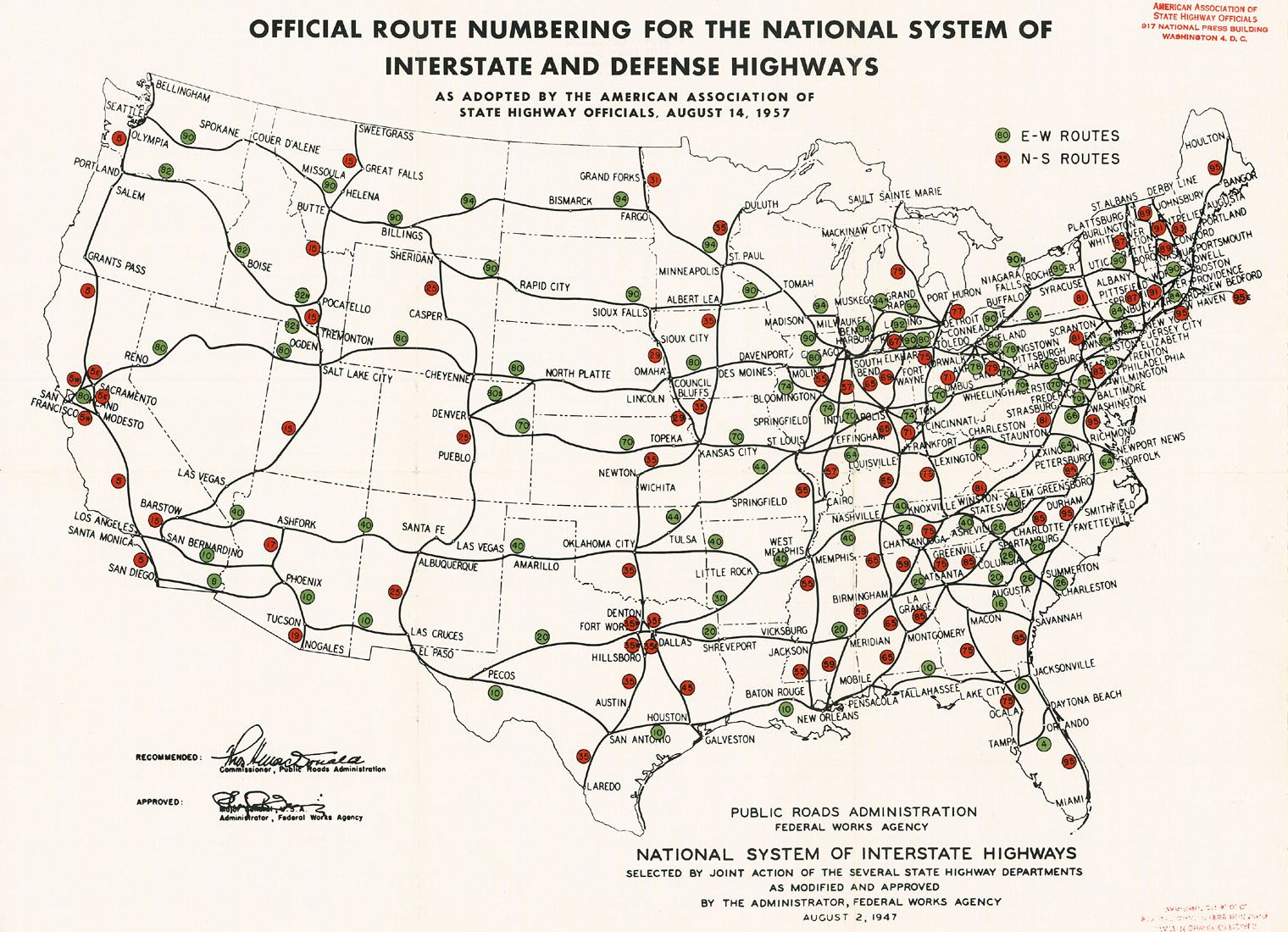
An east–west controlled access highway to serve the Northern United States was proposed in the early 20th century in several federal government documents, including reports from the Bureau of Public Roads in the 1930s and 1940s.[65][66] The Interstate Highway System was created by the Federal-Aid Highway Act of 1956, which was approved by the U.S. Congress and signed into law on June 26, 1956.[67] I-90 was assigned to the northernmost transcontinental route in the system by the American Association of State Highway Officials in 1957.[68][69]

The freeway would travel along existing parts of the United States Numbered Highway System, which was established at the suggestion of the federal government in 1926 to replace the named auto trails.[70] Among these auto trails, which were generally designated by private motorist organizations, were the transcontinental Yellowstone Trail and National Parks Highway, created in the 1910s along the future route of I-90 between Seattle and Boston.[71][72] The national numbered highways along the corridor included US 10 from Seattle to Billings, Montana; US 87 from Billings to Buffalo, Wyoming; US 16 from Buffalo to Portage, Wisconsin; US 51 from Portage to Rockford, Illinois and US 20 from Rockford to Boston.[73][74]

Tollways and urban construction edit

 
Aerial view of the Circle Interchange in Chicago during reconstruction in 2018

Major portions of I-90 in the Midwest and Northeastern states used existing toll roads built by state governments in the 1950s and 1960s. The Northwest Tollway, Chicago Skyway, Indiana Toll Road, Ohio Turnpike, New York State Thruway, and Massachusetts Turnpike all predate I-90 and were incorporated into the route.[75] This also meant that portions of the route did not adhere to Interstate Highway standards, but they were either deemed adequate or rebuilt to conform by the 1980s.[76] The Pennsylvania section was planned in the early 1950s as the "Erie Extension" of the Pennsylvania Turnpike,[77] but was instead completed as a toll-free road in October 1960 with federal funds.[78] The completion of the section also allowed for full use of the New York State Thruway, which had been finished three years earlier but ended abruptly at the state line.[79]

I-90 would use several expressways and tollways in the Chicago area, the earliest of which was the Tri-State Expressway (now the Kingery Expressway), completed in 1950 and extended into Indiana the following year.[80][81] It was followed by the Congress Expressway in the western suburbs, first opened in 1955, and the Northwest Tollway in 1958.[82][83] The last section to be completed in Illinois was the toll-free Dan Ryan Expressway, which opened on December 15, 1962, and was described as the "world's widest freeway" at the time.[84][85] In 1965, the designation for I-90 was switched with I-94 south of Chicago, which moved it to the tolled Chicago Skyway (completed in 1958);[86][87] the change was requested by the Illinois and Indiana state governments to avoid confusion and provide a continuous toll connection to the Indiana Toll Road,[88] which had been fully opened in 1956.[89] I-90 was moved onto the Kennedy Expressway in 1977 and its western route was replaced with I-290 from Schaumburg to the Circle Interchange in Chicago.[90][91]

The other tolled sections of I-90 were completed in the 1950s by their respective state governments. The 241-mile (388 km) Ohio Turnpike opened to traffic on October 1, 1955, three years after construction began.[92] The first segment of the New York Thruway opened in June 1954 and was followed by extensions to Buffalo and the Albany area by the end of the year.[93][94] It was extended to the Pennsylvania state line in 1957 and to the Massachusetts Turnpike via the Berkshire Connector in 1959.[95][96] The Berkshire section linked with the Massachusetts Turnpike, which had opened in 1957 from the state line to Newton, a distance of 123 miles (198 km).[97] The turnpike was extended into Boston in two stages: first by 9 miles (14 km) from Newton to Allston in September 1964;[98] and finally with an extension to I-93 near South Station in Downtown Boston that opened on February 18, 1965.[99]

Non-tolled construction edit

 
Construction sign on a section of I-90 in Montana

The freeway also incorporated other non-tolled expressway bypasses planned by state governments in the early 1950s and modified to meet Interstate standards. A bypass of Spokane Valley, Washington, opened in November 1956 as the first section in Washington and was extended into neighboring Spokane two years later.[100] Wisconsin opened their first section in November 1959, connecting the terminus of the Illinois Tollway with Janesville,[101] and extended the freeway through the Madison area to Wisconsin Dells in 1962.[102] The Cleveland Innerbelt opened in stages from 1959 to 1962 and was originally planned to connect with the Parma Freeway, which would have carried I-90 around the northwest side of Downtown Cleveland. It was later cancelled in the 1960s amid public opposition.[103][104] The first Minnesota section, built to bypass Austin, began construction in 1957 and opened in 1961.[105][106]

Wisconsin was among the first states to complete its rural Interstate system and opened its final section of I-90, from La Crosse to Tomah, in November 1969.[107][108] The section around Albany, New York, built as a toll-free alternative to the New York Thruway, was completed in 1976 with a connection to the Berkshire Connector, which had been originally intended to carry the I-90 designation across the Hudson River.[109][110] South Dakota completed its final section in November 1976, which created an unbroken stretch of four-lane highway from the Wyoming state line to Boston but some intersections remained.[111] The Minnesota segment of I-90 was declared complete in September 1978 with a dedication at Blue Earth, where a golden line was painted to emulate the golden spike of the first transcontinental railroad.[112] Two months later, Ohio finished its last section west of Cleveland.[113]

The western states were the last to complete their segments of I-90. Wyoming opened its final section, from the Montana state line to Sheridan, in July 1985 and dedicated it three months later following the completion of Montana's cross-border section.[114] The last two-lane section in Montana, near Springdale, was widened to four lanes in May 1987.[115] One of the last rural sections of I-90 to be built was through Wallace, Idaho, which placed its downtown on the National Register of Historic Places in 1976 to prevent its demolition for the freeway. The 1.5-mile (2.4 km) elevated freeway bypassed Wallace to the north and cost $42 million (equivalent to $81 million in 2022 dollars)[116] to construct. It opened on September 5, 1991, and the city ceremonially retired the last stoplight on I-90 a week later.[117][118] The Idaho section was declared fully complete in July 1992 after the Veterans Memorial Centennial Bridge opened near Coeur d'Alene.[119]

Completion and later projects edit

 
The Homer M. Hadley (left) and Lacey V. Murrow (right) floating bridges carry I-90 across Lake Washington from Seattle to Mercer Island.

Washington was the last state to complete its section of I-90, primarily due to disputes and litigation over the Seattle–Bellevue section.[10] The Snoqualmie Pass section was completed in 1981 with a viaduct for westbound traffic that stands 150 feet (46 m) over Denny Creek.[120] The viaduct replaced an earlier plan for a ground-level freeway at the behest of environmentalists; the Mountains to Sound Greenway was established in 1990 along the corridor between Seattle and Thorp to preserve wilderness and recreational areas and was designated as a National Scenic Byway in 1998, a first for an Interstate Highway.[121][122] The extension into Seattle was completed in stages between 1989 and 1993 and cost $1.56 billion (equivalent to $2.87 billion in 2022 dollars)[116] to construct.[123] The project involved construction of a new floating bridge, expansion of the Mount Baker Ridge Tunnel, addition of lids with parks, and extensive mitigation for environmental and social impacts.[10][124] The project was originally planned to be completed in 1992, but was delayed a year due to the sinking of the original floating bridge during renovations in November 1990; the bridge was rebuilt and opened for eastbound traffic on September 12, 1993.[10][125]

Extensions at both termini of I-90 were completed in the early 2000s as part of separate projects. The west end at Washington State Route 519 in Seattle was rebuilt as a series of ramps near Safeco Field (now T-Mobile Park) to replace an existing intersection.[126] A component of the Big Dig megaproject in Boston that extended I-90 east by 3.5 miles (5.6 km) under Fort Point Channel and Boston Harbor to Logan International Airport opened on January 18, 2003,[64] at a cost of $6.5 billion (equivalent to $9.96 billion in 2022 dollars).[116][127] The Fort Point Channel tunnel later closed in July 2006 due to a ceiling panel collapse that killed one person. It reopened in January 2007 after repairs and retrofit work.[128]

Other sections of I-90 have been rebuilt or replaced to accommodate modern needs and meet updated safety standards. The 11-mile (18 km) Dan Ryan Expressway in Chicago was reconstructed over a two-year period from 2006 to 2007 at a cost of $975 million (equivalent to $1.33 billion in 2022 dollars),[116] adding auxiliary lanes and improved bridges. The section carried over 300,000 daily vehicles prior to the project.[129] Cleveland's Innerbelt Bridge, which carried I-90 over the Cuyahoga River, was replaced with the George V. Voinovich Bridges, which opened in November 2013 for westbound traffic and September 2016 for eastbound traffic.[130] The old bridge was imploded with explosives on July 12, 2014, and dismantled by the end of the year.[131] The states of Minnesota and Wisconsin replaced the Dresbach Bridge over the Mississippi River in 2016; the project was spearheaded by Minnesota following the I-35W Mississippi River bridge collapse in 2007.[37]

Names and designations edit

 
AMVETS Memorial Highway sign on I-90 in New York

I-90 carries several commemorative names designated by state governments, some of which are shared between multiple states.[3] Washington and Minnesota designated their sections as the "American Veterans Memorial Highway".[132][133] In the states of Idaho,[134] Montana,[135] and South Dakota, I-90 is part of the Purple Heart Trail, which honors Purple Heart recipients.[136] In Wisconsin, I-90 and I-94 were designated as the Wisconsin Veterans Memorial Highway in 1987.[137] From Lorain, Ohio,[138] through Pennsylvania and New York, I-90 is officially designated as the "AMVETS Memorial Highway".[139][140]

Major intersections edit

Washington[9]
  SR 519 in downtown Seattle
  I-5 in downtown Seattle
  I-405 in Bellevue near Seattle
   I-82 / US 97 in Ellensburg
  US 395 in Ritzville; joined for 61 miles (98 km) until Spokane
   US 2 / US 395 in Spokane; joined for 4 miles (6.4 km)
Idaho[141]
  US 95 in Coeur d'Alene
Montana[16]
  US 93 near Missoula; joined for 5 miles (8.0 km)
  US 12 in Missoula; joined for 69 miles (111 km) until Garrison
  I-15 near Butte; joined for 8 miles (13 km) through Butte
  I-115 in Butte
  US 191 in Bozeman; joined for 58 miles (93 km) until Big Timber
  US 89 in Livingston; joined for 7 miles (11 km)
  US 212 in Laurel; joined for 77 miles (124 km) until Crow Agency
  US 87 in Billings; joined for 128 miles (206 km) until Sheridan, Wyoming
  I-94 near Billings
Wyoming[25]
  US 14 in Ranchester; joined for 16 miles (26 km) until Sheridan
  US 87 near Buffalo; joined for 12 miles (19 km)
  I-25 in Buffalo
   US 14 / US 16 in Gillette; joined for 25 miles (40 km) until Moorcroft
  US 14 in Sundance; joined for 132 miles (212 km) until Wall, South Dakota
South Dakota[30]
  US 85 in Spearfish; joined for 8 miles (13 km)
   I-190 / US 16 in Rapid City
  US 83 in Murdo; joined for 22 miles (35 km) until Vivian
  US 183 in Presho
  US 281 near Plankinton
  I-29 in Sioux Falls
  I-229 in Sioux Falls
Minnesota[35]
  US 75 in Luverne
  US 59 in Worthington
  US 71 in Jackson
  US 169 in Blue Earth
  I-35 in Albert Lea
  US 218 in Austin; joined for 3 miles (4.8 km)
  US 63 in Stewartville
  US 52 in Rochester
   US 14 / US 61 in Dakota; joined for 5 miles (8.0 km) until La Crescent
Wisconsin[39]
  US 53 in La Crosse; joined for 2 miles (3.2 km) until Onalaska
  US 12 in Tomah, Lyndon, and Delton
  I-94 in Tomah; joined for 92 miles (148 km) until Madison
  I-39 in Portage; joined for 95 miles (153 km) until Cherry Valley, Illinois
  US 51 in Burke
  US 151 in Madison
   US 12 / US 18 in Madison
  US 51 in Christiana; joined for 4 miles (6.4 km) until Albion
  I-43 in Beloit
Illinois[40]
  US 51 in South Beloit; joined for 17 miles (27 km) until Rockford
  US 20 in Hampshire
  I-290 in Schaumburg
  I-294 in Rosemont near Chicago
  I-190 to O'Hare International Airport near Chicago
  I-94 in Chicago; joined for 17 miles (27 km)
  I-290 in downtown Chicago
  I-55 in downtown Chicago
    US 12 / US 20 / US 41 near Chicago
Indiana[47]
  US 41 in Hammond
  US 12 in Gary
    I-65 / US 12 / US 20 in Gary
   I-94 / US 6 in Lake Station
  I-80 in Lake Station; joined for 278 miles (447 km) until Elyria, Ohio
  US 421 in New Durham Township
  US 31 in South Bend
  US 131 in York Township
  I-69 in Fremont
Ohio[48]
  US 20 in Maumee
  I-75 in Rossford near Toledo
  I-280 in Lake Township
  US 250 near Milan
  US 42 in Cleveland
  I-71 in Cleveland
  I-490 in Cleveland
  US 422 in downtown Cleveland
  I-77 in downtown Cleveland
  US 322 in downtown Cleveland
  US 6 in downtown Cleveland
  US 20 in Euclid
  I-271 in Willoughby Hills near Cleveland
Pennsylvania[51]
  US 6N in Springfield Township
  I-79 near Erie
  US 19 near Erie
  I-86 near Erie
  US 20 near North East
New York[52]
  US 20 in Hanover
  US 219 in West Seneca
  I-190 in Buffalo
  I-290 in Williamsville near Buffalo
  I-490 near Bergen
  I-390 near Rochester
  I-490 near Victor
  I-690 near Syracuse
  I-81 in Syracuse
  I-481 near Syracuse
  I-790 in Utica
  I-890 near Schenectady
  I-88 in Rotterdam
  I-890 near Schenectady
  I-87 in Albany
  US 9 in downtown Albany
  I-787 in downtown Albany
  US 4 in East Greenbush
   US 9 / US 20 in Schodack
Massachusetts[60]
  US 20 in Lee
  US 202 in Westfield
   I-91 / US 5 in West Springfield
  I-291 in Chicopee near Springfield
  I-84 in Sturbridge
   I-395 / I-290 in Auburn
  Route 146 in Millbury
  I-495 in Hopkinton
  I-95 in Weston
  I-93 in Boston
   Route 1A/Logan International Airport in Boston

Auxiliary routes edit

Source: FHWA[142]

I-90 in New York is the only Interstate Highway to have a complete set of auxiliary routes, all nine possible three-digit route numbers, within a single state.[2] Eight of the thirteen states that the highway passes through do not have auxiliary routes of I-90.[2]

See also edit

References edit

  1. ^ a b c "Table 1: Main Routes of the Dwight D. Eisenhower National System of Interstate and Defense Highways as of December 31, 2021". Route Log and Finder List. Federal Highway Administration. January 26, 2022. from the original on April 22, 2012. Retrieved February 10, 2022.
  2. ^ a b c d e f g h . Federal Highway Administration. 2010. Archived from the original on August 8, 2020. Retrieved November 28, 2021.
  3. ^ a b c d e f g h i j k Google (November 29, 2021). "Overview of Interstate 90" (Map). Google Maps. Google. Retrieved November 29, 2021.
  4. ^ FHWA Office of Transportation Policy Studies (September 2009). "Longer Combination Vehicles on Exclusive Truck Lanes: Interstate 90 Corridor Case Study". Federal Highway Administration. from the original on October 9, 2022. Retrieved December 9, 2021.
  5. ^ FHWA Office of Highway Policy Information (August 2013). "2011 Interstate Brief: Summary of the Interstate System by State and Route Number" (PDF). Federal Highway Administration. pp. 4, 15. (PDF) from the original on October 9, 2022. Retrieved April 3, 2022.
  6. ^ Lindblom, Mike (August 6, 2008). . The Seattle Times. p. B2. Archived from the original on June 16, 2018. Retrieved November 28, 2021.
  7. ^ a b Lee, Jessica (May 11, 2017). "From the archives: A look back at the I-90 floating bridges before light-rail work begins". The Seattle Times. from the original on November 29, 2021. Retrieved November 28, 2021.
  8. ^ Lindblom, Mike (March 10, 2023). "Sound Transit will shell out millions to keep pace with construction delays". The Seattle Times. from the original on August 24, 2023. Retrieved August 23, 2023.
  9. ^ a b c Washington State Department of Transportation (2014). Washington State Highways, 2014–2015 (PDF) (Map). 1:842,000. Olympia: Washington State Department of Transportation. Retrieved November 28, 2021.
  10. ^ a b c d Reynolds, Peggy (September 9, 1993). "Last link of I-90 ends 30-year saga". The Seattle Times. p. A10. from the original on October 5, 2021. Retrieved November 28, 2021.
  11. ^ Johnston, Steve (September 9, 1993). "Hey Johnston: What's that big concrete thing floating on Lake Washington?". The Seattle Times. p. 1. from the original on October 9, 2022. Retrieved November 28, 2021.
  12. ^ "Mountains to Sound Greenway National Heritage Area". National Park Service. from the original on November 29, 2021. Retrieved November 28, 2021.
  13. ^ Hill, Craig (January 10, 2014). "Snoqualmie opening benefits all". The News Tribune. p. A1. from the original on November 29, 2021. Retrieved November 28, 2021 – via Newspapers.com.
  14. ^ Titone, Julie (August 25, 1996). "Highway 95: From top to bottom, we explore Idaho's famed roadway". The Spokesman-Review. p. E1. from the original on September 14, 2023. Retrieved November 29, 2021.
  15. ^ "Bennett Bay Bridge offers best of form and function". The Transporter. Idaho Transportation Department. February 10, 2017. from the original on October 9, 2022. Retrieved November 30, 2021.
  16. ^ a b c d e Montana Official Highway Map (PDF) (Map). Scale not given. Helena: Montana Department of Transportation. 2021. (PDF) from the original on December 1, 2021. Retrieved November 29, 2021.
  17. ^ Gadbow, Daryl (July 22, 2004). "Gorgeous Gorge". The Missoulian. p. C1. from the original on November 29, 2021. Retrieved November 29, 2021 – via Newspapers.com.
  18. ^ Smith, Mike (September 22, 2016). "Slower speed limit in works for most of Homestake Pass". The Montana Standard. p. A1. from the original on November 29, 2021. Retrieved November 29, 2021 – via Newspapers.com.
  19. ^ Jokerst, Gail (June 10, 2001). "Headwaters haven: Three Forks a quaint slice of Montana's history". The Spokesman-Review. p. H4. from the original on November 29, 2021. Retrieved November 29, 2021 – via Newspapers.com.
  20. ^ Pyle, Richard (August 17, 2003). "The victors at Little Bighorn". The Philadelphia Inquirer. p. N5. from the original on November 29, 2021. Retrieved November 29, 2021 – via Newspapers.com.
  21. ^ Whitely, Peyton (December 10, 1995). "With a roar, Montana drops day speed limit". The Seattle Times. p. A1. from the original on November 29, 2021. Retrieved November 29, 2021.
  22. ^ Robbins, Jim (December 25, 1998). "Montana's Speed Limit of ?? M.P.H. Is Overturned as Too Vague". The New York Times. p. A20. from the original on November 29, 2021. Retrieved November 29, 2021.
  23. ^ Carter, Troy (October 1, 1995). . Bozeman Daily Chronicle. Archived from the original on November 29, 2021. Retrieved November 29, 2021.
  24. ^ "Speed limit upped to 80 mph on part of I-90 in NE Wyoming". Argus Leader. Sioux Falls. Associated Press. August 21, 2015. Retrieved November 29, 2021.
  25. ^ a b c Public Affairs Office (2011). Wyoming Highway Map (PDF) (Map). 1 inch = approx. 18 miles. Cheyenne: Wyoming Department of Transportation. (PDF) from the original on October 3, 2021. Retrieved November 29, 2021 – via Wyoming Office of Tourism.
  26. ^ Learn, Scott (July 1, 2012). "Coal clash: The Powder River Basin, where coal is king". The Oregonian. from the original on November 29, 2021. Retrieved November 29, 2021.
  27. ^ Eldredge, Kay (August 29, 1982). "The Spell of Devils Tower". The New York Times. sec. 10, p. 25. from the original on November 29, 2021. Retrieved November 29, 2021.
  28. ^ Henry, Neil (January 3, 1987). "Hush of the quiet season descends on the Black Hills". The Washington Post. Retrieved November 29, 2021.
  29. ^ Gordon, Kindra (June 11, 2006). "Get away from it all". Rapid City Journal. p. D1. from the original on November 29, 2021. Retrieved November 29, 2021 – via Newspapers.com.
  30. ^ a b c d State Highway Map of South Dakota (PDF) (Map). 1 inch = approx. 15.43 miles. Pierre: South Dakota Department of Transportation. 2019. (PDF) from the original on October 9, 2022. Retrieved November 29, 2021.
  31. ^ Motor Vehicle Use Map: Buffalo Gap National Grassland, South Dakota (PDF) (Map). Scale not given. Washington, D.C.: United States Forest Service. 2019. (PDF) from the original on November 29, 2021. Retrieved November 29, 2021.
  32. ^ Bures, Frank (March 21, 2013). "Spring Travel Issue: Cold War-era tourist sites feature weapons of mass attraction". The Washington Post. Retrieved November 29, 2021.
  33. ^ "From cowboys to missiles: Places to stop this summer on your I-90 road trip". Keloland.com. June 15, 2021. from the original on October 9, 2022. Retrieved November 29, 2021.
  34. ^ "Section 161.12: Additional Routes Added; Federal Aid". Minnesota Statutes. Minnesota Revisor's Office. 2021. from the original on November 30, 2021. Retrieved November 29, 2021.
  35. ^ a b c Minnesota 2021–2022 Official Highway Map (PDF) (Map). Scale not given. St. Paul: Minnesota Department of Transportation. 2021. (PDF) from the original on November 29, 2021. Retrieved November 29, 2021.
  36. ^ Stoll, Mike (May 26, 2017). "I-90 and the face of Mower County". Austin Daily Herald. from the original on October 9, 2022. Retrieved November 29, 2021.
  37. ^ a b Hubbuch, Chris (October 21, 2016). "Minnesota, Wisconsin celebrate completion of I-90 bridge". La Crosse Tribune. from the original on November 30, 2021. Retrieved November 29, 2021.
  38. ^ Noel, Josh (June 14, 2016). "A first-timer from Chicago dives into the Wisconsin Dells". Chicago Tribune. from the original on October 9, 2022. Retrieved November 29, 2021.
  39. ^ a b c Wisconsin 2019–2020 State Highway Map (PDF) (Map). 1 inch = approx. 13 miles. Madison: Wisconsin Department of Transportation. 2019. (PDF) from the original on January 29, 2022. Retrieved November 29, 2021.
  40. ^ a b c d Illinois Tollway 2020 Complimentary Map (PDF) (Map). Scale not given. Downers Grove: Illinois State Toll Highway Authority. January 2020. Chicago and Vicinity inset. (PDF) from the original on November 30, 2021. Retrieved November 29, 2021.
  41. ^ a b Hilkevitch, Jon (December 5, 2013). "O'Hare Blue Line to stay open during 4-year renovation". Chicago Tribune. from the original on October 9, 2022. Retrieved November 29, 2021.
  42. ^ Hilkevitch, Jon (August 22, 2011). "Drivers frustrated by Kennedy express lanes". Chicago Tribune. sec. 1, p. 4. from the original on November 30, 2021. Retrieved November 29, 2021.
  43. ^ Wronski, Richard (November 23, 2015). "Kennedy Expressway tops new list of nation's most congested highways". Chicago Tribune. from the original on November 30, 2021. Retrieved November 29, 2021.
  44. ^ "Urban Highways with the Most Lanes" (PDF). Federal Highway Administration. July 27, 2010. (PDF) from the original on January 6, 2022. Retrieved December 3, 2021.
  45. ^ Hilkevitch, Jon (March 26, 2006). "Buckle up, it looks like a long ride". Chicago Tribune. sec. 1, p. 10. from the original on October 9, 2022. Retrieved December 3, 2021 – via Newspapers.com.
  46. ^ Channick, Robert (January 31, 2017). "IIT sells oldest building for redevelopment". Chicago Tribune. from the original on November 30, 2021. Retrieved November 29, 2021.
  47. ^ a b c d Indiana Roadway Map 2021 (PDF) (Map). Scale not given. Indianapolis: Indiana Department of Transportation. 2021. (PDF) from the original on November 2, 2021. Retrieved November 30, 2021.
  48. ^ a b c d ODOT Office of Technical Services (April 2019). Ohio Official Transportation Map (PDF) (Map). 1 inch = 11 miles. Columbus: Ohio Department of Transportation. Cleveland inset. (PDF) from the original on July 14, 2021. Retrieved November 30, 2021.
  49. ^ Grant, Alison (November 8, 2013). "Inner Belt Bridge brings crowd of onlookers with cameras, babies in strollers". The Plain Dealer. from the original on November 30, 2021. Retrieved November 30, 2021.
  50. ^ Naymik, Mark (August 3, 2021). "Cleveland's Dead Man's Curve not getting straightened any time soon: Mark Naymik Reports". WKYC. Retrieved November 30, 2021.
  51. ^ a b c PennDOT Bureau of Planning and Research (2020). Pennsylvania Tourism and Transportation Map (PDF) (Map). Scale not given. Harrisburg: Pennsylvania Department of Transportation. (PDF) from the original on November 30, 2021. Retrieved November 30, 2021.
  52. ^ a b c d (PDF) (Map). Scale not given. Cartography by Maps.com. Albany: New York State Department of Economic Development. 2001. inset. Archived from the original (PDF) on December 31, 2009. Retrieved November 30, 2021.
  53. ^ a b (PDF). National Park Service. 2020. pp. 4–5. Archived from the original (PDF) on December 1, 2021. Retrieved November 30, 2021.
  54. ^ O'Donnell, Harry (June 25, 1950). "Thruway to Surpass Pennsylvania Turnpike". Rochester Democrat and Chronicle. p. 13A. from the original on December 1, 2021. Retrieved November 30, 2021 – via Newspapers.com.
  55. ^ Syracuse Metropolitan Transportation Council (June 2016). 2016 Highway Map of Onondaga County, New York (PDF) (Map). Scale not given. Syracuse: Onondaga County Department of Transportation. (PDF) from the original on October 9, 2022. Retrieved November 30, 2021.
  56. ^ a b "Interchange/Exit Listings". New York State Thruway Authority. from the original on September 8, 2021. Retrieved November 30, 2021.
  57. ^ Rubel, Abigail (September 27, 2021). "Getting There: Will New York change its highway exit numbers?". Times Union. from the original on December 1, 2021. Retrieved November 30, 2021.
  58. ^ "50 Years of freedom". Overdrive. May 31, 2006. from the original on December 1, 2021. Retrieved November 30, 2021.
  59. ^ "Tennessee's Interstate System – Frequently Asked Questions". Tennessee Department of Transportation. 2006. from the original on December 1, 2021. Retrieved November 30, 2021.
  60. ^ a b c d e MassDOT Central Transportation Planning Staff (2019). Massachusetts Official Transportation Map (Map). 1 inch = 6 miles. Boston: Massachusetts Department of Transportation. from the original on December 1, 2021. Retrieved November 30, 2021.
  61. ^ Carlinsky, Dan (September 21, 1975). "...And Back Roads Of Massachusetts". The New York Times. sec. 10, p. 1. from the original on December 1, 2021. Retrieved November 30, 2021.
  62. ^ Rubin, Eilhu (May 27, 2012). "How to look at the Prudential". The Boston Globe. from the original on December 1, 2021. Retrieved November 30, 2021.
  63. ^ a b Flint, Anthony (December 29, 2015). "10 years later, did the Big Dig deliver?". The Boston Globe. from the original on December 5, 2020. Retrieved November 30, 2021.
  64. ^ a b "The Big Dig: tunnels and bridges". Massachusetts Department of Transportation. from the original on December 1, 2021. Retrieved November 30, 2021.
  65. ^ Miller, James N. (July 23, 1939). "14,000 Mile Super Highway To Speed Transportation". The Seattle Times. p. 3.
  66. ^ Pfeiffer, David A. (Summer 2006). "Ike's Interstates at 50". Prologue. National Archives and Records Administration. pp. 14–18. ISSN 0033-1031. OCLC 321015582. from the original on March 2, 2011. Retrieved April 11, 2022.
  67. ^ Weingroff, Richard F. (2006). "Designating the Urban Interstates". Federal Highway Administration. from the original on December 30, 2017. Retrieved November 30, 2021.
  68. ^ American Association of State Highway Officials (August 14, 1957). Official Route Numbering for the National System of Interstate and Defense Highways (Map). Scale not given. Washington, D.C.: Public Roads Administration. from the original on May 3, 2021. Retrieved November 30, 2021 – via Wikimedia Commons.
  69. ^ Hodenfield, G. K. (September 26, 1957). "New Markers to Dot Super Roads". The Indianapolis News. p. 1. from the original on November 29, 2021. Retrieved November 30, 2021 – via Newspapers.com.
  70. ^ Weingroff, Richard F. "From Names to Numbers: The Origins of the U.S. Numbered Highway System". Highway History. Federal Highway Administration. from the original on September 1, 2019. Retrieved December 9, 2021.
  71. ^ Westgard, A. L. (June 7, 1919). "Let's Go: Here Are the Motor Trails from Atlantic to Pacific—and All Points Between". The Independent. Vol. 98, no. 3678. pp. 360–361, 379. OCLC 4927591. from the original on October 9, 2022. Retrieved December 9, 2021 – via Google Books.
  72. ^ Burkhart, Dan (February 17, 1998). "Interstate 90 had rough, rutted forerunner". Great Falls Tribune. p. 8M. from the original on December 9, 2021. Retrieved December 9, 2021 – via Newspapers.com.
  73. ^ Joint Board on Interstate Highways (1925). "Appendix VI: Descriptions of the Interstate Routes Selected, with Numbers Assigned". Report of Joint Board on Interstate Highways, October 30, 1925, Approved by the Secretary of Agriculture, November 18, 1925. Washington, D.C.: United States Department of Agriculture. pp. 50–56. OCLC 733875457, 55123355, 71026428. Archived from the original on November 14, 2017. Retrieved December 9, 2021 – via Wikisource.
  74. ^ Bureau of Public Roads; American Association of State Highway Officials (November 11, 1926). United States System of Highways Adopted for Uniform Marking by the American Association of State Highway Officials (Map). 1:7,000,000. Washington, DC: United States Geological Survey. OCLC 32889555. Archived from the original on April 13, 2017. Retrieved December 9, 2021 – via Wikimedia Commons.
  75. ^ Ingraham, Joseph C. (May 24, 1959). "Boston to Chicago: New Section of Thruway Completes Express Route Between Cities". The New York Times. p. XX1. from the original on July 22, 2018. Retrieved December 4, 2021.
  76. ^ Gough, William (September 30, 1987). "Across the lake in concrete: A ride on new I-90 span bridges a gap in the imagination". The Seattle Times. p. E1.
  77. ^ Snyder, Thomas P. (September 7, 1953). "Turnpike Link to Erie Assured, Survey of Best Route Begins". Pittsburgh Sun-Telegraph. p. 8. from the original on October 9, 2022. Retrieved December 1, 2021 – via Newspapers.com.
  78. ^ "Erie Throughway Is Scheduled To Be Officially Open Friday". The Titusville Herald. October 24, 1960. p. 3. from the original on December 1, 2021. Retrieved December 1, 2021 – via Newspapers.com.
  79. ^ White, William A. (October 28, 1960). "'Dead-End' Thruway Is Opened At Erie". The Pittsburgh Press. p. 4. from the original on December 1, 2021. Retrieved December 1, 2021 – via Newspapers.com.
  80. ^ Foust, Hal (October 23, 1950). "First Section of Expressway Will Open Nov. 1". Chicago Tribune. sec. 1, p. 14. from the original on October 9, 2022. Retrieved December 9, 2021 – via Newspapers.com.
  81. ^ "Schricker, Stevenson Open Super-Highway Link". The Hammond Times. December 14, 1951. p. 1. from the original on December 4, 2021. Retrieved December 9, 2021 – via Newspapers.com.
  82. ^ Foust, Hal (December 10, 1955). "Show 4.5 Mile Congress St. Stretch to Be Opened to Traffic Tuesday". Chicago Tribune. sec. 1, p. 3. from the original on October 9, 2022. Retrieved December 9, 2021 – via Newspapers.com.
  83. ^ "Traffic Rolls on 76 Miles of Tollways". Chicago Tribune. August 21, 1958. sec. 1, p. 1. from the original on December 3, 2021. Retrieved December 9, 2021 – via Newspapers.com.
  84. ^ Foust, Hal (December 16, 1962). "Drivers Jam Expressway on First Day". Chicago Tribune. sec. 1, p. 1. from the original on December 9, 2021. Retrieved December 9, 2021 – via Newspapers.com.
  85. ^ Sullivan, Mort J. (December 13, 1962). "Dan Ryan Expressway Will Open Saturday". Chicago Daily Herald. United Press International. p. 24. from the original on December 9, 2021. Retrieved December 9, 2021 – via Newspapers.com.
  86. ^ Rand McNally (1965). 1965 Illinois Official Highway Map (PDF) (Map). 1 inch = 12 miles. Springfield: Illinois Division of Highways. Chicago and Vicinity inset. (PDF) from the original on November 7, 2021. Retrieved December 9, 2021.
  87. ^ Foust, Hal (April 17, 1958). "A Great Day For Chicago! Skyway Open". Chicago Tribune. sec. 1, p. 1. from the original on October 9, 2022. Retrieved December 9, 2021 – via Newspapers.com.
  88. ^ "An Application From the State Highway Department of Indiana For the Relocation of Interstate Route I-90". American Association of State Highway Officials. February 27, 1964. from the original on October 2, 2020. Retrieved December 9, 2021 – via AASHTO Route Numbering Archive.
  89. ^ "No Fanfare As Final Indiana Toll Link Opens; Semi-Trailer, State Police Car 1st Customers". The Hammond Times. November 16, 1956. p. 1. from the original on December 4, 2021. Retrieved December 9, 2021 – via Newspapers.com.
  90. ^ Special Committee on U.S. Route Numbering (July 6, 1977). "Route Numbering Committee Agenda" (PDF) (Report). Washington, DC: American Association of State Highway and Transportation Officials. p. 5. Retrieved December 9, 2021 – via Wikimedia Commons.
  91. ^ Illinois Department of Transportation (1979). Illinois Highway Map (Map). [1:772,500]. Springfield: Illinois Department of Transportation. Chicago and Vicinity inset. Retrieved April 11, 2022 – via Illinois Digital Archives.
  92. ^ Cram, Winston (October 1, 1955). "Midnight Ceremony Opens Turnpike; Traffic Swarms On Ohio 'Main Street'". Toledo Blade. p. 1. from the original on December 9, 2021. Retrieved December 9, 2021 – via Google News Archive.
  93. ^ Ingraham, Joseph C. (June 23, 1954). "Thruway to Open Officially Today". The New York Times. p. 29. from the original on October 9, 2022. Retrieved December 9, 2021.
  94. ^ Ingraham, Joseph C. (October 24, 1954). "More Thruway: Newburgh-Utica Link Opens Tuesday, Bringing Pike Within 61 Miles of City". The New York Times. p. X19. from the original on December 4, 2021. Retrieved December 9, 2021.
  95. ^ "The Thruway Becomes the Longest Toll Road". The New York Times. December 15, 1957. p. 159. from the original on October 9, 2022. Retrieved December 9, 2021.
  96. ^ Weaver, Warren Jr. (May 27, 1959). "Thruway Opened to New England". The New York Times. p. 20. from the original on December 4, 2021. Retrieved December 9, 2021.
  97. ^ Ingraham, Joseph C. (May 12, 1957). "Bay State's Turnpike Link". The New York Times. p. XX3. from the original on October 9, 2022. Retrieved December 4, 2021.
  98. ^ Plotkin, A. S. (September 4, 1964). "Hot Debate Preceded Building of Toll Link". The Boston Globe. p. 12. from the original on December 4, 2021. Retrieved December 4, 2021 – via Newspapers.com.
  99. ^ Hanron, Robert B. (February 19, 1965). "East-West Gateway Swings Open; 60 M.P.H. Through Boston..." The Boston Globe. p. 1. from the original on December 4, 2021. Retrieved December 4, 2021 – via Newspapers.com.
  100. ^ Dieffenbach, Al (November 16, 1961). "Freeway is Five: Traffic Benefits Are Listed". Spokane Daily Chronicle. p. 1. from the original on December 1, 2021. Retrieved December 9, 2021 – via Newspapers.com.
  101. ^ Foust, Hal (November 25, 1959). "Opens 18 Miles of Interstate Expressway". Chicago Tribune. sec. 1, p. 8. from the original on December 3, 2021. Retrieved December 9, 2021 – via Newspapers.com.
  102. ^ Foust, Hal (November 3, 1962). "Expressway From Chicago to Dells Open". Chicago Tribune. sec. 1, p. 16. from the original on December 3, 2021. Retrieved December 9, 2021 – via Newspapers.com.
  103. ^ "Innerbelt Freeway". Encyclopedia of Cleveland History. Case Western Reserve University. May 11, 2018. from the original on December 4, 2021. Retrieved December 9, 2021.
  104. ^ Grant, Alison (May 6, 2015). "Big Creek bike-pedestrian greenway eyed for vicinity of abandoned 'Parma Freeway'". The Plain Dealer. from the original on December 10, 2021. Retrieved December 9, 2021.
  105. ^ "Road Construction Near Austin Part of East-West Belt Route". The Minneapolis Star. October 2, 1957. p. 6B. from the original on October 9, 2022. Retrieved December 9, 2021 – via Newspapers.com.
  106. ^ "Beltline at Austin Opened". Winona Daily News. Associated Press. November 9, 1961. p. 10. from the original on December 3, 2021. Retrieved December 9, 2021 – via Newspapers.com.
  107. ^ "I-94 segment observes 50th anniversary". Red Wing Republican Eagle. October 22, 2009. from the original on October 9, 2022. Retrieved December 9, 2021.
  108. ^ Wolski, Wayne (November 4, 1969). "I-90 Rites Open 4-Laner To Area". La Crosse Tribune. p. 1. from the original on December 3, 2021. Retrieved December 9, 2021 – via Newspapers.com.
  109. ^ "New York State Department of Transportation Annual Report, 1976" (PDF). New York State Department of Transportation. 1977. p. 7. from the original on October 9, 2022. Retrieved December 9, 2021 – via New York State Library.
  110. ^ O'Brien, Tim (March 25, 2010). . Times Union. Archived from the original on February 13, 2016. Retrieved December 9, 2021.
  111. ^ "I-90 ceremony to be held near Spearfish". Mitchell Daily Republic. November 19, 1976. p. 5. from the original on December 3, 2021. Retrieved December 9, 2021 – via Newspapers.com.
  112. ^ Coleman, Nick (September 24, 1978). "Blue Earth puts Golden Spike in Interstate 90". Minneapolis Tribune. pp. 1A, 16A. from the original on December 3, 2021. Retrieved December 9, 2021 – via Newspapers.com.
  113. ^ Hosie, Ron (November 4, 1978). "Heckler draws retort from Rhodes". Dayton Daily News. p. 3. from the original on October 9, 2022. Retrieved December 9, 2021 – via Newspapers.com.
  114. ^ Thackeray, Lorna (October 10, 1985). "Governors plan Interstate 90 christening". The Billings Gazette. p. 2B. from the original on December 10, 2021. Retrieved December 9, 2021 – via Newspapers.com.
  115. ^ "I-90 finally done". Great Falls Tribune. Associated Press. May 14, 1987. p. 9A. from the original on October 9, 2022. Retrieved December 9, 2021 – via Newspapers.com.
  116. ^ a b c d Johnston, Louis; Williamson, Samuel H. (2023). "What Was the U.S. GDP Then?". MeasuringWorth. Retrieved November 30, 2023. United States Gross Domestic Product deflator figures follow the Measuring Worth series.
  117. ^ Devlin, Sherry (September 8, 1991). "No Stopping Now". The Missoulian. p. E1. from the original on December 10, 2021. Retrieved December 9, 2021 – via Newspapers.com.
  118. ^ Free, Cathy (September 15, 1991). "Engineer pleased with his Wallace freeway 'work of art'". The Spokesman-Review. p. B3. from the original on October 9, 2022. Retrieved November 28, 2021 – via Newspapers.com.
  119. ^ Foster, J. Todd (July 4, 1992). "New I-90 stretch offers scenery, safety". The Spokesman-Review. p. A1. from the original on December 10, 2021. Retrieved December 9, 2021 – via Newspapers.com.
  120. ^ O'Ryan, John (December 4, 1981). "Cars whiz along on feared bridge". Seattle Post-Intelligencer. p. C1.
  121. ^ Senos, Rene (April 18, 2002). "Blending scenery and ecology". Seattle Daily Journal of Commerce. from the original on October 9, 2022. Retrieved December 1, 2021.
  122. ^ Ott, Jennifer (May 18, 2021). "Mountains to Sound Greenway Trust". HistoryLink. from the original on October 9, 2022. Retrieved December 1, 2021.
  123. ^ Cabrera, Luis (September 11, 1993). "Floating bridge finishes interstate". Detroit Free Press. Associated Press. p. 5A. from the original on August 3, 2018. Retrieved August 2, 2018 – via Newspapers.com.
  124. ^ Corr, O. Casey (June 2, 1989). "The road to recovery—new homes, new park". Seattle Post-Intelligencer. p. A1.
  125. ^ Gough, William (June 22, 1989). "That'll be one bridge—to go". The Seattle Times. p. A1.
  126. ^ Lindblom, Mike (May 29, 2003). "Some I-90 drivers get turned around". The Seattle Times. p. A1.
  127. ^ Lewis, Raphael (January 18, 2003). . The Boston Globe. p. A1. Archived from the original on January 24, 2003. Retrieved December 9, 2021.
  128. ^ Jefferson, Brandie M. (January 14, 2007). "Traffic begins flowing through Big Dig tunnel where woman died". The Boston Globe. Associated Press. from the original on December 10, 2021. Retrieved December 9, 2021.
  129. ^ Haggerty, Ryan (October 26, 2007). . Chicago Tribune. sec. 2, p. 2. Archived from the original on December 27, 2007. Retrieved December 10, 2021.
  130. ^ Christ, Ginger (September 14, 2016). "Second George V. Voinovich Bridge (Inner Belt Bridge) opens to traffic Sept. 25". The Plain Dealer. from the original on December 10, 2021. Retrieved December 10, 2021.
  131. ^ Grant, Alison (July 12, 2014). "55-year-old Inner Belt Bridge vanishes in a half second". The Plain Dealer. from the original on December 10, 2021. Retrieved December 10, 2021.
  132. ^ "RCW 47.17.140: State route No. 90—American Veterans Memorial Highway—Washington green highway". Revised Code of Washington. Washington State Legislature. 1991. from the original on December 1, 2021. Retrieved December 1, 2021.
  133. ^ MnDOT Office of Transportation System Management (October 17, 2019). Memorial Highways & Bridges (PDF) (Map). Scale not given. St. Paul: Minnesota Department of Transportation. (PDF) from the original on December 1, 2021. Retrieved November 30, 2021.
  134. ^ "Idaho Statues 40-513C: Designation of Purple Heart Trail". Idaho Legislature. 2008. from the original on December 1, 2021. Retrieved December 1, 2021.
  135. ^ "§ 60-1-210: Purple Heart Trail". Montana Code Annotated 2014. Montana Legislature. from the original on December 1, 2021. Retrieved December 1, 2021.
  136. ^ "Interstate 90 dedication set for 'Purple Heart Trail'". Rapid City Journal. August 5, 2012. from the original on December 1, 2021. Retrieved December 1, 2021.
  137. ^ "Commemorative highways and bridges". Wisconsin Department of Transportation. from the original on December 1, 2021. Retrieved November 30, 2021.
  138. ^ "Ohio Revised Code Section 5533.35: Amvets highway" (PDF). Ohio Revised Code. Ohio General Assembly. August 4, 1978. (PDF) from the original on November 30, 2021. Retrieved December 1, 2021.
  139. ^ "P.L. 453, No. 110: AMVETS Memorial Highway – Designation". Pennsylvania Unconsolidated Statutes. Pennsylvania General Assembly. July 11, 1990. from the original on December 1, 2021. Retrieved December 1, 2021.
  140. ^ "Thruway Ceremony Planned for May 17". Hamburg Sun. May 9, 1991. p. 10. from the original on December 1, 2021. Retrieved December 1, 2021 – via Newspapers.com.
  141. ^ Idaho Official State Highway Map (PDF) (Map). 1:1,248,000. Boise: Idaho Transportation Department. 2021. (PDF) from the original on April 18, 2022. Retrieved April 11, 2022.
  142. ^ "Table 2: Auxiliary Routes of the Dwight D. Eisenhower National System Of Interstate and Defense Highways as of December 31, 2021". Route Log and Finder List. Federal Highway Administration. January 26, 2022. from the original on July 3, 2017. Retrieved February 10, 2022.

External links edit

KML is from Wikidata
  •   Geographic data related to Interstate 90 at OpenStreetMap
  • I-90 at Interstate-Guide.com

interstate, east, west, transcontinental, freeway, longest, interstate, highway, united, states, miles, begins, seattle, washington, travels, through, pacific, northwest, mountain, west, great, plains, midwest, northeast, ending, boston, massachusetts, highway. Interstate 90 I 90 is an east west transcontinental freeway and the longest Interstate Highway in the United States at 3 021 miles 4 862 km It begins in Seattle Washington and travels through the Pacific Northwest Mountain West Great Plains Midwest and the Northeast ending in Boston Massachusetts The highway serves 13 states and has 15 auxiliary routes primarily in major cities such as Chicago Cleveland Buffalo and Rochester Interstate 90Map of the contiguous United States with I 90 highlighted in redRoute informationLength3 021 22 mi 1 4 862 18 km Existed1956 presentNHSEntire routeMajor junctionsWest endSR 519 in Seattle WAMajor intersectionsI 5 in Seattle WA I 15 near Butte MT I 25 near Buffalo WY I 35 in Albert Lea MN I 55 in Chicago IL I 65 in Gary IN I 80 I 94 US 6 in Lake Station IN I 75 in Rossford OH I 80 in Elyria OH I 95 in Weston MAEast endRoute 1A Logan International Airport in Boston MALocationCountryUnited StatesStatesWashington Idaho Montana Wyoming South Dakota Minnesota Wisconsin Illinois Indiana Ohio Pennsylvania New York MassachusettsHighway systemInterstate Highway SystemMain Auxiliary Suffixed Business FutureI 90 begins at Washington State Route 519 in Seattle and crosses the Cascade Range in Washington and the Rocky Mountains in Montana It then traverses the northern Great Plains and travels southeast through Wisconsin and the Chicago area by following the southern shore of Lake Michigan The freeway continues across Indiana and follows the shore of Lake Erie through Ohio and Pennsylvania to Buffalo I 90 travels across New York by roughly following the historic Erie Canal and traverses Massachusetts reaching its eastern terminus at Massachusetts Route 1A near Logan International Airport in Boston The freeway was established by the Federal Aid Highway Act of 1956 replacing a series of existing U S highways that had been preceded by local roads and auto trails established in the early 20th century I 90 was numbered in 1957 reflecting its status as the northernmost transcontinental route of the system and construction was underway on several sections with funding from the Federal Aid Highway Act The route also incorporates several toll roads that predate the Interstate Highway System including the Jane Addams Memorial Tollway Indiana Toll Road Ohio Turnpike New York State Thruway and the Massachusetts Turnpike These toll roads opened in the 1950s and were followed by toll free sections in Pennsylvania and Wisconsin that were finished in the 1960s The Midwestern sections of I 90 were fully completed in 1978 and most of the route between Seattle and South Dakota opened by 1987 The final section near the western terminus in Seattle opened in September 1993 an eastern extension in Boston was completed in 2003 as part of the Big Dig project Contents 1 Route description 1 1 Washington 1 2 Idaho 1 3 Montana 1 4 Wyoming 1 5 South Dakota 1 6 Minnesota 1 7 Wisconsin 1 8 Illinois 1 9 Indiana 1 10 Ohio 1 11 Pennsylvania 1 12 New York 1 13 Massachusetts 2 History 2 1 Predecessors and establishment 2 2 Tollways and urban construction 2 3 Non tolled construction 2 4 Completion and later projects 3 Names and designations 4 Major intersections 5 Auxiliary routes 6 See also 7 References 8 External linksRoute description editLengths mi 1 kmWA 296 92 477 85ID 73 55 118 37MT 552 46 889 10WY 208 80 336 03SD 412 76 664 27MN 275 70 443 70WI 108 61 174 79IL 123 89 199 38IN 156 28 251 51OH 244 75 393 89PA 46 30 74 51NY 385 48 620 37MA 135 72 218 42Total 3 021 22 4 862 18I 90 is the longest Interstate Highway in the United States spanning 3 021 miles 4 862 km across the northern portion of the coterminous part of the country 2 The transcontinental freeway passes through 13 states in the Pacific Northwest Mountain West Great Plains Midwest and the Northeast regions of the United States 2 3 From the Wisconsin Illinois state line to Massachusetts approximately 760 miles 1 220 km of I 90 uses turnpikes and other tolled highways with the exception of segments in Chicago northeastern Ohio Pennsylvania and Albany New York The toll road sections comprise 25 percent of the freeway s total length 2 4 According to 2011 data from the Federal Highway Administration the busiest section of I 90 is in the Chicago area where a daily average of 306 574 vehicles use the freeway The lowest daily traffic counts on I 90 were recorded in Wyoming where an average of 9 820 vehicles used rural sections of the freeway 5 Washington edit Main article Interstate 90 in Washington nbsp Aerial view of I 90 near North Bend WashingtonThe western terminus of I 90 is at an intersection with Washington State Route 519 and 4th Avenue South in the SoDo neighborhood of Seattle The junction is south of Downtown Seattle adjacent to the Port of Seattle and two major sports stadiums Lumen Field and T Mobile Park 6 The freeway travels east through an interchange with I 5 and around Beacon Hill before it enters the Mount Baker Ridge Tunnel alongside the future 2 Line of the Link light rail system set to open in 2025 7 8 I 90 emerges from the tunnel on a pair of floating bridges among the longest of their kind the eastbound only Lacey V Murrow Memorial Bridge and the Homer M Hadley Memorial Bridge which carries westbound traffic and the future light rail line 7 9 The floating bridges cross Lake Washington to Mercer Island where I 90 travels through a series of tunnels under 14 acres 5 7 ha of parkland including Aubrey Davis Park 10 11 The freeway continues from the island and enters Bellevue the largest city of the Eastside region and intersects I 405 near Factoria I 90 then travels along Lake Sammamish and through Issaquah as it leaves the Seattle metropolitan area and ascends into the Cascade Range on the Mountains to Sound Greenway a designated National Heritage Area and National Scenic Byway 12 The freeway crosses Snoqualmie Pass elevation 3 022 feet 921 m at the crest of the mountain range near a ski resort 13 From Snoqualmie Pass I 90 follows the Yakima River into the Kittitas Valley and intersects I 82 in Ellensburg after a brief concurrency with U S Route 97 US 97 The highway crosses the Columbia River on the Vantage Bridge and turns northeast to climb the cliffs of the Columbia Plateau near George After traveling east across Moses Lake and the surrounding agricultural region I 90 begins a long concurrency with US 395 at Ritzville as the highways turn northeast towards Spokane I 90 US 395 is joined by US 2 through western Spokane where it intersects US 195 The freeway crosses downtown Spokane on an elevated viaduct and splits from US 2 and US 395 to continue east across Spokane Valley towards the Idaho state line 9 Idaho edit Main article Interstate 90 in Idaho nbsp The viaduct bypassing Wallace Idaho opened in 1991 as one of the last sections of I 90 I 90 traverses the Idaho Panhandle region at the north end of the state where it connects Coeur d Alene to communities in the Silver Valley From the Washington state line the freeway follows the Spokane River through Post Falls and Huetter to the city of Coeur d Alene where it intersects US 95 the state s main north south highway 14 I 90 then turns southeast to bypass Coeur d Alene and travel along a series of ridges that face Lake Coeur d Alene crossing an arm of the lake on the Veterans Memorial Centennial Bridge 3 15 The freeway continues east across Fourth of July Summit and descends into the Silver Valley where it follows the Coeur d Alene River through several small towns along the historic Mullan Road I 90 serves the cities of Kellogg and Wallace before it ascends into the Bitterroot Range and crosses Lookout Pass which also marks the Montana state line 3 Montana edit Main article Interstate 90 in Montana nbsp I 90 at Lookout Pass on the Idaho Montana borderMontana has the longest section of I 90 at almost 552 miles 888 km despite the highway only serving a portion of the state s east west width 1 16 It descends from Lookout Pass along the St Regis and Clark Fork rivers between the foothills of the Bitteroot Range and Coeur d Alene Mountains The freeway travels east through the Alberton Gorge and crosses the Clark Fork River several times before it reaches the head of the Missoula Valley 17 After a short concurrency with US 93 I 90 runs along the north side of Missoula and joins US 12 to continue southeast along the foothills of the Garnet Range and Sapphire Mountains 16 After it splits from US 12 in Garrison the freeway turns south to traverse the Deer Lodge Valley It then turns east to serve Butte where it overlaps with I 15 for eight miles 13 km and intersects I 115 I 90 then continues southeast and crosses the Rocky Mountains and Continental Divide at Homestake Pass which is the highest point on the entire Interstate at 6 329 feet 1 929 m 18 The freeway travels east across the Jefferson Valley and passes the headwaters of the Missouri River near Three Forks It then enters the Gallatin Valley 16 19 I 90 travels around Bozeman where it is joined by US 191 and crosses Bozeman Pass between the Bridger and Gallatin mountains At the east end of the mountains the freeway begins to follow the Yellowstone River and is briefly concurrent with US 89 which serves Yellowstone National Park and splits from US 191 at Big Timber I 90 continues along the Yellowstone River through Billings overlapping with US 87 and US 212 until it reaches Lockwood the western terminus of I 94 The freeways split and I 90 continues east across the Bighorn Basin before it turns south near Hardin to follow the Little Bighorn River into the Crow Indian Reservation The highway passes the site of the Battle of the Little Bighorn near Crow Agency and continues south along the river and the Wolf Mountains into Wyoming 16 20 From 1995 to 1999 there was no numbered daytime speed limit on rural highways in Montana including I 90 21 The speed limit was simply defined as reasonable and proper as determined on a case by case basis by the Montana Highway Patrol until the Montana Supreme Court ruled it was unconstitutional 22 The maximum daytime speed limit in Montana was initially set at 75 mph 120 km h in 1999 and was later raised to 80 mph 130 km h in 2015 23 Wyoming edit Main article Interstate 90 in Wyoming nbsp View of southern Sheridan Wyoming from I 90I 90 serves a portion of northeastern Wyoming that is primarily rural 24 The freeway briefly concurrent to US 14 travels southeast along a series of creeks to Sheridan in the northeastern foothills of the Bighorn Mountains I 90 and US 87 split in Sheridan and travel parallel to each other to Fort Phil Kearny where they rejoin and continue south past Lake Desmet to Buffalo The highways split again near Buffalo at a junction with I 25 which overlaps with US 87 to Casper 25 From Buffalo the highway turns east to cross the Powder River Basin a region with several large coal mines 26 I 90 then reaches Gillette where it begins a concurrency with US 14 and US 16 to a three way split in Moorcroft The freeway continues into the Bear Lodge Mountains part of the Black Hills and is rejoined in Sundance by US 14 which looped north to serve the Devils Tower 27 I 90 US 14 then continues northeast to Beulah where it enters South Dakota 25 South Dakota edit Main article Interstate 90 in South Dakota nbsp The Lewis and Clark Memorial Bridge which carries I 90 over the Missouri River near Chamberlain South DakotaI 90 US 14 enters South Dakota near Spearfish and travels east through prairie land where it is briefly concurrent with US 85 Beyond Sturgis the freeway turns south and follows the edge of the Black Hills to Rapid City the gateway to Mount Rushmore 28 It then skirts the northern edge of Rapid City which is served by spur route I 190 and passes Ellsworth Air Force Base while it continues east across the plains I 90 splits from US 14 near Wall home to the Wall Drug roadside attraction and located northeast of Badlands National Park 29 30 The freeway travels southeast into the Buffalo Gap National Grassland and also passes a pair of decommissioned missile silos that form the Minuteman Missile National Historic Site 31 32 I 90 continues east along the top of a plateau that faces the White River and passes near Kadoka and Murdo US 83 briefly joins the highway from Murdo to Vivian where it splits off to serve the state capital of Pierre 30 It then crosses the Missouri River on the Lewis and Clark Memorial Bridge near Chamberlain and passes a rest area which overlooks the river and includes the 50 foot 15 m Dignity statue 33 From Chamberlain I 90 continues east across the plains and past several small towns near the city of Mitchell It then reaches the Sioux Falls area where it bypasses the city to the north and intersects I 29 and I 229 I 90 leaves Sioux Falls and crosses into Minnesota near Brandon 30 Minnesota edit Main article Interstate 90 in Minnesota nbsp Historic marker to commemorate the completion of I 90 in 1978 near Blue Earth MinnesotaI 90 crosses the southern portion of Minnesota and carries unsigned Legislative Route 391 across the state 34 From the South Dakota border near Beaver Creek to Albert Lea the freeway travels east across farmland and towns in the plains and rolling hills of the Buffalo Ridge It also intersects several north south highways including US 75 in Luverne US 59 in Worthington US 71 in Jackson and US 169 in Blue Earth I 90 travels around the northern outskirts of Albert Lea and intersects I 35 northeast of the city It then reaches Austin and a brief concurrency with US 218 35 From Austin the freeway turns northeast to head towards Rochester which it bypasses to the south and intersects US 63 and US 52 I 90 continues east into the hilly Driftless Area and descends from the bluffs that overlook Lake Onalaska on the Mississippi River 36 It turns southeast at Dakota and is joined by US 14 until the highways split near La Crescent I 90 turns east before it reaches La Crescent where it crosses the Mississippi River on the Dresbach Bridge into Wisconsin 35 37 Wisconsin edit Main article Interstate 90 in Wisconsin nbsp I 90 Mississippi River bridge near La CrosseI 90 enters Wisconsin near La Crosse and bisects French Island before it reaches Onalaska This section is briefly concurrent to US 53 between La Crosse and Onalaska The freeway travels east generally along the La Crosse River through several towns and Fort McCoy before it reaches a junction with I 94 in Tomah The two Interstates join at Tomah and travel southeast along the edge of the hills of the Western Upland following the Lemonweir and Wisconsin rivers It passes Wisconsin Dells situated on the gorge of the same name and home to several water parks and theme parks 38 39 The freeway travels east from Wisconsin Dells to the Portage area where I 39 begins its concurrency with I 90 I 94 The highway then crosses the Wisconsin River and travels south towards Madison where it forms an eastern bypass of the city East of Madison I 94 separates from I 39 I 90 which continues southeast through Edgerton and Janesville The highway turns south and enters Beloit where it intersects I 43 and crosses into Illinois 39 Illinois edit Main article Interstate 90 in Illinois nbsp The Kennedy Expressway looking southeast towards the Chicago skylineI 90 uses several sections of the Illinois Tollway system as it traverses the northeastern corner of the state primarily in the Chicago metropolitan area It enters the state from Beloit Wisconsin and remains concurrent to I 39 and US 51 on the Jane Addams Memorial Tollway through the eastern outskirts of Rockford where the highways split off I 90 continues on the tollway as it follows US 20 southeast through Belvidere and Elgin in the Fox Valley 40 The tollway cuts through the northwestern suburbs of Chicago where it intersects I 290 in Schaumburg and passes the north side of O Hare International Airport On the east side of the airport in Rosemont I 90 intersects I 294 and I 190 the latter of which serves the airport s passenger terminals and marks the end of the tollway 40 The freeway now named the Kennedy Expressway travels through northwestern Chicago where the Blue Line of the L rapid transit system runs in the median and serves several stops 41 I 90 turns southeast and is rejoined by I 94 in Irving Park where it gains a set of reversible express lanes that travel for 6 2 miles 10 0 km toward the Near West Side 42 The Kennedy Expressway travels south through the Near West Side opposite the Chicago River from the Chicago Loop the city s central business district and intersects I 290 again at the Jane Byrne Interchange 43 The freeway continues onto the Dan Ryan Expressway and crosses the Chicago River near Chinatown and an interchange with I 55 The Dan Ryan is the widest section of I 90 at 12 through lanes and is split between local and express lanes 44 45 I 90 I 94 is joined by the L Red Line in the median of the expressway through the city s South Side 41 where it passes Guaranteed Rate Field the Illinois Institute of Technology campus and Washington Park 46 I 90 splits from the Dan Ryan Expressway in Englewood and turns southeast onto the tolled Chicago Skyway The tolled Skyway travels towards the Indiana state line which the freeway crosses near the Calumet River in the East Side 3 40 Indiana edit Main article Indiana Toll Road nbsp A section of the Indiana Toll Road carrying I 90 in Gary IndianaThe entirety of I 90 within Indiana is concurrent with the Indiana Toll Road which crosses the state s northern fringe and is mostly shared with I 80 47 From the Illinois state line the tollway travels south through Hammond and turns east to follow the Grand Calumet River through northern Gary where it intersects US 41 and US 12 I 90 then crosses I 65 in eastern Gary and I 94 in Lake Station where it begins a concurrency with I 80 47 I 94 travels northeast near the Lake Michigan shoreline from Lake Station to Michigan City while the Indiana Toll Road I 80 I 90 follows it to the south The tollway then moves closer to the Michigan Indiana state line and turns east passing through the northern outskirts of South Bend and Elkhart In South Bend it intersects US 31 and passes near the University of Notre Dame I 80 I 90 travels parallel to the state line until it reaches an interchange with I 69 near Fremont where it turns southeast The tollway then turns east and crosses the Ohio state line near Angola 47 Ohio edit Main article Interstate 90 in Ohio See also Ohio Turnpike nbsp Aerial view of Ohio Turnpike exit 142 showing the connector between I 90 and I 80 on the turnpikeAt the state line near Montpelier I 80 I 90 transitions from the Indiana Toll Road to the Ohio Turnpike which crosses northern Ohio The highway continues east around several rural towns as it approaches the Toledo area The turnpike crosses under I 475 in Maumee without an interchange access to I 475 is instead provided through a nearby junction with US 20 I 80 I 90 then continues southeast across the Maumee River to Rossford on the southern outskirts of Toledo where it intersects I 75 48 The turnpike travels southeast through a rural area near the southwest shore of Lake Erie where it passes the cities of Fremont and Sandusky Near Norwalk the highway turns northeast to follow State Route 2 SR 2 and heads to Elyria where I 90 splits from I 80 which remains on the turnpike The freeway then merges with SR 2 and continues northeast through the lakeshore suburbs west of Cleveland including Rocky River and Lakewood I 90 and SR 2 separate after crossing the Rocky River and travel parallel to each other as they enter Cleveland I 90 continues through the southwestern residential neighborhoods of Cleveland and reaches a junction with I 71 and I 490 in Tremont where it turns north 48 From Tremont I 90 turns north onto the Innerbelt Freeway and crosses the Cuyahoga River into Downtown Cleveland on the George V Voinovich Bridges 49 The Innerbelt skirts the south side of Downtown Cleveland where it intersects I 77 near Progressive Field and turns north to bisect the Goodrich Kirtland Park neighborhood 3 Near Cleveland Burke Lakefront Airport the freeway makes a sharp 90 degree turn nicknamed Dead Man s Curve for its frequent crashes 50 and rejoins SR 2 on the Cleveland Memorial Shoreway until they split again in Euclid I 90 briefly turns southeast but resumes its northeastern route after a junction with I 271 in Willoughby Hills The freeway travels parallel to the Lake Erie shoreline through farmland and exurban towns and crosses into Pennsylvania near Conneaut 48 Pennsylvania edit Main article Interstate 90 in Pennsylvania Within Pennsylvania I 90 is non tolled and generally travels northeast around several communities on the Lake Erie shoreline and remains entirely in Erie County 51 It enters the state in Springfield Township and passes through rural areas along the lake shore parallel to US 20 and the Lake Road The freeway then travels through the southern outskirts of Erie where it intersects I 79 and US 19 I 90 returns to the rural areas of northeastern Erie County and intersects I 86 before it reaches the New York state line near the borough of North East 51 At 46 miles 74 km the Pennsylvania section is I 90 s shortest within a single state 2 New York edit Main article Interstate 90 in New York See also New York State Thruway nbsp The New York State Thruway near AmsterdamI 90 enters New York in Chautauqua County and runs concurrently with the mainline of the tolled New York State Thruway It travels northeast along the Lake Erie shoreline between Lake Road to the north and US 20 to the south through Dunkirk and Fredonia The highways enter the Buffalo area where the toll road runs north south through Cheektowaga and forms an eastern bypass using auxiliary routes I 190 and I 290 to serve the city 3 52 At a junction with I 290 near Buffalo Niagara International Airport I 90 turns east to follow the historic Water Level Route of the New York Central Railroad itself parallel to the 19th century Erie Canal 53 54 The Thruway passes south of Rochester which it serves via a loop on I 490 and the direct north south spur I 390 I 90 travels through the Finger Lakes region and moves closer to the Erie Canal as it approaches the Syracuse area It travels through the city s northern outskirts where it intersects I 690 I 81 and I 481 from west to east 55 It then continues to Utica where the Thruway runs along the north side of the Mohawk River part of the Erie Canal 53 The section through Utica connected to the city s downtown via I 790 was built between the lines of SR 49 which does not merge with the Thruway 3 I 90 then closely follows the Mohawk River southeast through several towns and villages between the foothills of the Catskill and Adirondack mountains The Thruway then reaches Schenectady which it bypasses to the southwest and intersects I 88 and I 890 the latter of which serves the city s downtown The highway continues southeast into Albany to a junction with I 87 where I 90 splits from the Thruway which turns south to serve New York City 52 I 90 travels east as a toll free freeway through the northern neighborhoods of Albany and intersects I 787 before it crosses the Hudson River into Rensselaer The freeway travels south around Rensselaer and rejoins the Thruway via the Berkshire Connector which continues east into the Taconic Mountains towards the Massachusetts state line 3 52 The mileposts and sequential exit numbers on the New York State Thruway mainline originate from New York City increasing northward on I 87 and westward on I 90 56 as a result the mileposts and exit numbers on I 90 through most of New York run backwards compared to the federal preference for mile based numbers increasing from west to east 57 The Berkshire Connector uses west to east mileposts and exit numbers with a B prefix 56 the toll free section of I 90 through Albany and Rensselaer uses conventional west to east mileposts and exit numbers despite being geographically north south 3 I 90 is currently the only Interstate that has a complete set of nine spur routes within one state all numbers being used 2 In addition I 990 a short spur route near Buffalo that is not directly connected to I 90 is the highest number given to an Interstate 58 59 Massachusetts edit Main article Massachusetts Turnpike nbsp View of the Massachusetts Turnpike in Boston s Fenway Kenmore neighborhood seen from the Prudential Tower Fenway Park is visible at top leftI 90 in Massachusetts is concurrent with the entirety of the Massachusetts Turnpike also known as the Pike or MassPike 60 The turnpike begins at the New York state line in West Stockbridge and travels southeast through the Berkshires to the Pioneer Valley 61 The highway travels through the northern suburbs of Springfield where it intersects I 91 and crosses the Connecticut River into Chicopee I 90 then crosses over I 391 without an interchange and serves as the northern terminus of I 291 on the eastern outskirts of the city The turnpike continues east through the hills of Central Massachusetts and serves as the eastern terminus of I 84 in the town of Sturbridge 60 From Sturbridge the turnpike travels northeast towards Worcester and passes through the city s southern outskirts It serves as the respective northern and western terminus of I 395 and I 290 in Auburn located southwest of Worcester and continues to an interchange with I 495 near Westborough at the edge of Greater Boston I 90 travels through the western suburbs of Boston and travels through Framingham before it intersects I 95 Route 128 the main beltway around Boston on the border of Weston and Newton 60 The turnpike continues along the Charles River into Boston where it descends into a tunnel that passes Boston University Fenway Park and under the Prudential Tower complex in the Back Bay neighborhood 3 62 I 90 intersects I 93 on the south side of Downtown Boston and travels under the Fort Point Channel to serve the Seaport District The turnpike then enters the Ted Williams Tunnel which travels northeast under Boston Harbor to the passenger terminals at Logan International Airport 63 After it passes the northwest side of the airport I 90 terminates at an interchange with Route 1A in East Boston 60 The section between I 93 and the airport was opened in the early 2000s as part of the Big Dig megaproject 63 which rebuilt several Boston freeways and extended I 90 by 3 5 miles 5 6 km 2 64 History editPredecessors and establishment edit An east west controlled access highway to serve the Northern United States was proposed in the early 20th century in several federal government documents including reports from the Bureau of Public Roads in the 1930s and 1940s 65 66 The Interstate Highway System was created by the Federal Aid Highway Act of 1956 which was approved by the U S Congress and signed into law on June 26 1956 67 I 90 was assigned to the northernmost transcontinental route in the system by the American Association of State Highway Officials in 1957 68 69 The freeway would travel along existing parts of the United States Numbered Highway System which was established at the suggestion of the federal government in 1926 to replace the named auto trails 70 Among these auto trails which were generally designated by private motorist organizations were the transcontinental Yellowstone Trail and National Parks Highway created in the 1910s along the future route of I 90 between Seattle and Boston 71 72 The national numbered highways along the corridor included US 10 from Seattle to Billings Montana US 87 from Billings to Buffalo Wyoming US 16 from Buffalo to Portage Wisconsin US 51 from Portage to Rockford Illinois and US 20 from Rockford to Boston 73 74 Tollways and urban construction edit nbsp Aerial view of the Circle Interchange in Chicago during reconstruction in 2018Major portions of I 90 in the Midwest and Northeastern states used existing toll roads built by state governments in the 1950s and 1960s The Northwest Tollway Chicago Skyway Indiana Toll Road Ohio Turnpike New York State Thruway and Massachusetts Turnpike all predate I 90 and were incorporated into the route 75 This also meant that portions of the route did not adhere to Interstate Highway standards but they were either deemed adequate or rebuilt to conform by the 1980s 76 The Pennsylvania section was planned in the early 1950s as the Erie Extension of the Pennsylvania Turnpike 77 but was instead completed as a toll free road in October 1960 with federal funds 78 The completion of the section also allowed for full use of the New York State Thruway which had been finished three years earlier but ended abruptly at the state line 79 I 90 would use several expressways and tollways in the Chicago area the earliest of which was the Tri State Expressway now the Kingery Expressway completed in 1950 and extended into Indiana the following year 80 81 It was followed by the Congress Expressway in the western suburbs first opened in 1955 and the Northwest Tollway in 1958 82 83 The last section to be completed in Illinois was the toll free Dan Ryan Expressway which opened on December 15 1962 and was described as the world s widest freeway at the time 84 85 In 1965 the designation for I 90 was switched with I 94 south of Chicago which moved it to the tolled Chicago Skyway completed in 1958 86 87 the change was requested by the Illinois and Indiana state governments to avoid confusion and provide a continuous toll connection to the Indiana Toll Road 88 which had been fully opened in 1956 89 I 90 was moved onto the Kennedy Expressway in 1977 and its western route was replaced with I 290 from Schaumburg to the Circle Interchange in Chicago 90 91 The other tolled sections of I 90 were completed in the 1950s by their respective state governments The 241 mile 388 km Ohio Turnpike opened to traffic on October 1 1955 three years after construction began 92 The first segment of the New York Thruway opened in June 1954 and was followed by extensions to Buffalo and the Albany area by the end of the year 93 94 It was extended to the Pennsylvania state line in 1957 and to the Massachusetts Turnpike via the Berkshire Connector in 1959 95 96 The Berkshire section linked with the Massachusetts Turnpike which had opened in 1957 from the state line to Newton a distance of 123 miles 198 km 97 The turnpike was extended into Boston in two stages first by 9 miles 14 km from Newton to Allston in September 1964 98 and finally with an extension to I 93 near South Station in Downtown Boston that opened on February 18 1965 99 Non tolled construction edit nbsp Construction sign on a section of I 90 in MontanaThe freeway also incorporated other non tolled expressway bypasses planned by state governments in the early 1950s and modified to meet Interstate standards A bypass of Spokane Valley Washington opened in November 1956 as the first section in Washington and was extended into neighboring Spokane two years later 100 Wisconsin opened their first section in November 1959 connecting the terminus of the Illinois Tollway with Janesville 101 and extended the freeway through the Madison area to Wisconsin Dells in 1962 102 The Cleveland Innerbelt opened in stages from 1959 to 1962 and was originally planned to connect with the Parma Freeway which would have carried I 90 around the northwest side of Downtown Cleveland It was later cancelled in the 1960s amid public opposition 103 104 The first Minnesota section built to bypass Austin began construction in 1957 and opened in 1961 105 106 Wisconsin was among the first states to complete its rural Interstate system and opened its final section of I 90 from La Crosse to Tomah in November 1969 107 108 The section around Albany New York built as a toll free alternative to the New York Thruway was completed in 1976 with a connection to the Berkshire Connector which had been originally intended to carry the I 90 designation across the Hudson River 109 110 South Dakota completed its final section in November 1976 which created an unbroken stretch of four lane highway from the Wyoming state line to Boston but some intersections remained 111 The Minnesota segment of I 90 was declared complete in September 1978 with a dedication at Blue Earth where a golden line was painted to emulate the golden spike of the first transcontinental railroad 112 Two months later Ohio finished its last section west of Cleveland 113 The western states were the last to complete their segments of I 90 Wyoming opened its final section from the Montana state line to Sheridan in July 1985 and dedicated it three months later following the completion of Montana s cross border section 114 The last two lane section in Montana near Springdale was widened to four lanes in May 1987 115 One of the last rural sections of I 90 to be built was through Wallace Idaho which placed its downtown on the National Register of Historic Places in 1976 to prevent its demolition for the freeway The 1 5 mile 2 4 km elevated freeway bypassed Wallace to the north and cost 42 million equivalent to 81 million in 2022 dollars 116 to construct It opened on September 5 1991 and the city ceremonially retired the last stoplight on I 90 a week later 117 118 The Idaho section was declared fully complete in July 1992 after the Veterans Memorial Centennial Bridge opened near Coeur d Alene 119 Completion and later projects edit nbsp The Homer M Hadley left and Lacey V Murrow right floating bridges carry I 90 across Lake Washington from Seattle to Mercer Island Washington was the last state to complete its section of I 90 primarily due to disputes and litigation over the Seattle Bellevue section 10 The Snoqualmie Pass section was completed in 1981 with a viaduct for westbound traffic that stands 150 feet 46 m over Denny Creek 120 The viaduct replaced an earlier plan for a ground level freeway at the behest of environmentalists the Mountains to Sound Greenway was established in 1990 along the corridor between Seattle and Thorp to preserve wilderness and recreational areas and was designated as a National Scenic Byway in 1998 a first for an Interstate Highway 121 122 The extension into Seattle was completed in stages between 1989 and 1993 and cost 1 56 billion equivalent to 2 87 billion in 2022 dollars 116 to construct 123 The project involved construction of a new floating bridge expansion of the Mount Baker Ridge Tunnel addition of lids with parks and extensive mitigation for environmental and social impacts 10 124 The project was originally planned to be completed in 1992 but was delayed a year due to the sinking of the original floating bridge during renovations in November 1990 the bridge was rebuilt and opened for eastbound traffic on September 12 1993 10 125 Extensions at both termini of I 90 were completed in the early 2000s as part of separate projects The west end at Washington State Route 519 in Seattle was rebuilt as a series of ramps near Safeco Field now T Mobile Park to replace an existing intersection 126 A component of the Big Dig megaproject in Boston that extended I 90 east by 3 5 miles 5 6 km under Fort Point Channel and Boston Harbor to Logan International Airport opened on January 18 2003 64 at a cost of 6 5 billion equivalent to 9 96 billion in 2022 dollars 116 127 The Fort Point Channel tunnel later closed in July 2006 due to a ceiling panel collapse that killed one person It reopened in January 2007 after repairs and retrofit work 128 Other sections of I 90 have been rebuilt or replaced to accommodate modern needs and meet updated safety standards The 11 mile 18 km Dan Ryan Expressway in Chicago was reconstructed over a two year period from 2006 to 2007 at a cost of 975 million equivalent to 1 33 billion in 2022 dollars 116 adding auxiliary lanes and improved bridges The section carried over 300 000 daily vehicles prior to the project 129 Cleveland s Innerbelt Bridge which carried I 90 over the Cuyahoga River was replaced with the George V Voinovich Bridges which opened in November 2013 for westbound traffic and September 2016 for eastbound traffic 130 The old bridge was imploded with explosives on July 12 2014 and dismantled by the end of the year 131 The states of Minnesota and Wisconsin replaced the Dresbach Bridge over the Mississippi River in 2016 the project was spearheaded by Minnesota following the I 35W Mississippi River bridge collapse in 2007 37 Names and designations edit nbsp AMVETS Memorial Highway sign on I 90 in New YorkI 90 carries several commemorative names designated by state governments some of which are shared between multiple states 3 Washington and Minnesota designated their sections as the American Veterans Memorial Highway 132 133 In the states of Idaho 134 Montana 135 and South Dakota I 90 is part of the Purple Heart Trail which honors Purple Heart recipients 136 In Wisconsin I 90 and I 94 were designated as the Wisconsin Veterans Memorial Highway in 1987 137 From Lorain Ohio 138 through Pennsylvania and New York I 90 is officially designated as the AMVETS Memorial Highway 139 140 Major intersections editWashington 9 nbsp SR 519 in downtown Seattle nbsp I 5 in downtown Seattle nbsp I 405 in Bellevue near Seattle nbsp nbsp I 82 US 97 in Ellensburg nbsp US 395 in Ritzville joined for 61 miles 98 km until Spokane nbsp nbsp US 2 US 395 in Spokane joined for 4 miles 6 4 km Idaho 141 nbsp US 95 in Coeur d Alene Montana 16 nbsp US 93 near Missoula joined for 5 miles 8 0 km nbsp US 12 in Missoula joined for 69 miles 111 km until Garrison nbsp I 15 near Butte joined for 8 miles 13 km through Butte nbsp I 115 in Butte nbsp US 191 in Bozeman joined for 58 miles 93 km until Big Timber nbsp US 89 in Livingston joined for 7 miles 11 km nbsp US 212 in Laurel joined for 77 miles 124 km until Crow Agency nbsp US 87 in Billings joined for 128 miles 206 km until Sheridan Wyoming nbsp I 94 near Billings Wyoming 25 nbsp US 14 in Ranchester joined for 16 miles 26 km until Sheridan nbsp US 87 near Buffalo joined for 12 miles 19 km nbsp I 25 in Buffalo nbsp nbsp US 14 US 16 in Gillette joined for 25 miles 40 km until Moorcroft nbsp US 14 in Sundance joined for 132 miles 212 km until Wall South Dakota South Dakota 30 nbsp US 85 in Spearfish joined for 8 miles 13 km nbsp nbsp I 190 US 16 in Rapid City nbsp US 83 in Murdo joined for 22 miles 35 km until Vivian nbsp US 183 in Presho nbsp US 281 near Plankinton nbsp I 29 in Sioux Falls nbsp I 229 in Sioux Falls Minnesota 35 nbsp US 75 in Luverne nbsp US 59 in Worthington nbsp US 71 in Jackson nbsp US 169 in Blue Earth nbsp I 35 in Albert Lea nbsp US 218 in Austin joined for 3 miles 4 8 km nbsp US 63 in Stewartville nbsp US 52 in Rochester nbsp nbsp US 14 US 61 in Dakota joined for 5 miles 8 0 km until La Crescent Wisconsin 39 nbsp US 53 in La Crosse joined for 2 miles 3 2 km until Onalaska nbsp US 12 in Tomah Lyndon and Delton nbsp I 94 in Tomah joined for 92 miles 148 km until Madison nbsp I 39 in Portage joined for 95 miles 153 km until Cherry Valley Illinois nbsp US 51 in Burke nbsp US 151 in Madison nbsp nbsp US 12 US 18 in Madison nbsp US 51 in Christiana joined for 4 miles 6 4 km until Albion nbsp I 43 in Beloit Illinois 40 nbsp US 51 in South Beloit joined for 17 miles 27 km until Rockford nbsp US 20 in Hampshire nbsp I 290 in Schaumburg nbsp I 294 in Rosemont near Chicago nbsp I 190 to O Hare International Airport near Chicago nbsp I 94 in Chicago joined for 17 miles 27 km nbsp I 290 in downtown Chicago nbsp I 55 in downtown Chicago nbsp nbsp nbsp US 12 US 20 US 41 near Chicago Indiana 47 nbsp US 41 in Hammond nbsp US 12 in Gary nbsp nbsp nbsp I 65 US 12 US 20 in Gary nbsp nbsp I 94 US 6 in Lake Station nbsp I 80 in Lake Station joined for 278 miles 447 km until Elyria Ohio nbsp US 421 in New Durham Township nbsp US 31 in South Bend nbsp US 131 in York Township nbsp I 69 in Fremont Ohio 48 nbsp US 20 in Maumee nbsp I 75 in Rossford near Toledo nbsp I 280 in Lake Township nbsp US 250 near Milan nbsp US 42 in Cleveland nbsp I 71 in Cleveland nbsp I 490 in Cleveland nbsp US 422 in downtown Cleveland nbsp I 77 in downtown Cleveland nbsp US 322 in downtown Cleveland nbsp US 6 in downtown Cleveland nbsp US 20 in Euclid nbsp I 271 in Willoughby Hills near Cleveland Pennsylvania 51 nbsp US 6N in Springfield Township nbsp I 79 near Erie nbsp US 19 near Erie nbsp I 86 near Erie nbsp US 20 near North East New York 52 nbsp US 20 in Hanover nbsp US 219 in West Seneca nbsp I 190 in Buffalo nbsp I 290 in Williamsville near Buffalo nbsp I 490 near Bergen nbsp I 390 near Rochester nbsp I 490 near Victor nbsp I 690 near Syracuse nbsp I 81 in Syracuse nbsp I 481 near Syracuse nbsp I 790 in Utica nbsp I 890 near Schenectady nbsp I 88 in Rotterdam nbsp I 890 near Schenectady nbsp I 87 in Albany nbsp US 9 in downtown Albany nbsp I 787 in downtown Albany nbsp US 4 in East Greenbush nbsp nbsp US 9 US 20 in Schodack Massachusetts 60 nbsp US 20 in Lee nbsp US 202 in Westfield nbsp nbsp I 91 US 5 in West Springfield nbsp I 291 in Chicopee near Springfield nbsp I 84 in Sturbridge nbsp nbsp I 395 I 290 in Auburn nbsp Route 146 in Millbury nbsp I 495 in Hopkinton nbsp I 95 in Weston nbsp I 93 in Boston nbsp nbsp Route 1A Logan International Airport in BostonAuxiliary routes editSource FHWA 142 Rapid City South Dakota I 190 Chicago Illinois I 190 I 290 Cleveland Ohio I 490 Buffalo New York I 190 I 290 I 990 not directly connected Rochester New York I 390 I 490 I 590 not directly connected Syracuse New York I 690 Utica New York I 790 Schenectady New York I 890 Worcester Massachusetts I 290 I 190 not directly connected I 90 in New York is the only Interstate Highway to have a complete set of auxiliary routes all nine possible three digit route numbers within a single state 2 Eight of the thirteen states that the highway passes through do not have auxiliary routes of I 90 2 See also editBusiness routes of Interstate 90References edit a b c Table 1 Main Routes of the Dwight D Eisenhower National System of Interstate and Defense Highways as of December 31 2021 Route Log and Finder List Federal Highway Administration January 26 2022 Archived from the original on April 22 2012 Retrieved February 10 2022 a b c d e f g h Eisenhower Interstate Highway System Previous Facts of the Day Federal Highway Administration 2010 Archived from the original on August 8 2020 Retrieved November 28 2021 a b c d e f g h i j k Google November 29 2021 Overview of Interstate 90 Map Google Maps Google Retrieved November 29 2021 FHWA Office of Transportation Policy Studies September 2009 Longer Combination Vehicles on Exclusive Truck Lanes Interstate 90 Corridor Case Study Federal Highway Administration Archived from the original on October 9 2022 Retrieved December 9 2021 FHWA Office of Highway Policy Information August 2013 2011 Interstate Brief Summary of the Interstate System by State and Route Number PDF Federal Highway Administration pp 4 15 Archived PDF from the original on October 9 2022 Retrieved April 3 2022 Lindblom Mike August 6 2008 Port clears way for I 90 link to waterfront The Seattle Times p B2 Archived from the original on June 16 2018 Retrieved November 28 2021 a b Lee Jessica May 11 2017 From the archives A look back at the I 90 floating bridges before light rail work begins The Seattle Times Archived from the original on November 29 2021 Retrieved November 28 2021 Lindblom Mike March 10 2023 Sound Transit will shell out millions to keep pace with construction delays The Seattle Times Archived from the original on August 24 2023 Retrieved August 23 2023 a b c Washington State Department of Transportation 2014 Washington State Highways 2014 2015 PDF Map 1 842 000 Olympia Washington State Department of Transportation Retrieved November 28 2021 a b c d Reynolds Peggy September 9 1993 Last link of I 90 ends 30 year saga The Seattle Times p A10 Archived from the original on October 5 2021 Retrieved November 28 2021 Johnston Steve September 9 1993 Hey Johnston What s that big concrete thing floating on Lake Washington The Seattle Times p 1 Archived from the original on October 9 2022 Retrieved November 28 2021 Mountains to Sound Greenway National Heritage Area National Park Service Archived from the original on November 29 2021 Retrieved November 28 2021 Hill Craig January 10 2014 Snoqualmie opening benefits all The News Tribune p A1 Archived from the original on November 29 2021 Retrieved November 28 2021 via Newspapers com Titone Julie August 25 1996 Highway 95 From top to bottom we explore Idaho s famed roadway The Spokesman Review p E1 Archived from the original on September 14 2023 Retrieved November 29 2021 Bennett Bay Bridge offers best of form and function The Transporter Idaho Transportation Department February 10 2017 Archived from the original on October 9 2022 Retrieved November 30 2021 a b c d e Montana Official Highway Map PDF Map Scale not given Helena Montana Department of Transportation 2021 Archived PDF from the original on December 1 2021 Retrieved November 29 2021 Gadbow Daryl July 22 2004 Gorgeous Gorge The Missoulian p C1 Archived from the original on November 29 2021 Retrieved November 29 2021 via Newspapers com Smith Mike September 22 2016 Slower speed limit in works for most of Homestake Pass The Montana Standard p A1 Archived from the original on November 29 2021 Retrieved November 29 2021 via Newspapers com Jokerst Gail June 10 2001 Headwaters haven Three Forks a quaint slice of Montana s history The Spokesman Review p H4 Archived from the original on November 29 2021 Retrieved November 29 2021 via Newspapers com Pyle Richard August 17 2003 The victors at Little Bighorn The Philadelphia Inquirer p N5 Archived from the original on November 29 2021 Retrieved November 29 2021 via Newspapers com Whitely Peyton December 10 1995 With a roar Montana drops day speed limit The Seattle Times p A1 Archived from the original on November 29 2021 Retrieved November 29 2021 Robbins Jim December 25 1998 Montana s Speed Limit of M P H Is Overturned as Too Vague The New York Times p A20 Archived from the original on November 29 2021 Retrieved November 29 2021 Carter Troy October 1 1995 Montana interstate speed limit raised to 80 mph mostly Bozeman Daily Chronicle Archived from the original on November 29 2021 Retrieved November 29 2021 Speed limit upped to 80 mph on part of I 90 in NE Wyoming Argus Leader Sioux Falls Associated Press August 21 2015 Retrieved November 29 2021 a b c Public Affairs Office 2011 Wyoming Highway Map PDF Map 1 inch approx 18 miles Cheyenne Wyoming Department of Transportation Archived PDF from the original on October 3 2021 Retrieved November 29 2021 via Wyoming Office of Tourism Learn Scott July 1 2012 Coal clash The Powder River Basin where coal is king The Oregonian Archived from the original on November 29 2021 Retrieved November 29 2021 Eldredge Kay August 29 1982 The Spell of Devils Tower The New York Times sec 10 p 25 Archived from the original on November 29 2021 Retrieved November 29 2021 Henry Neil January 3 1987 Hush of the quiet season descends on the Black Hills The Washington Post Retrieved November 29 2021 Gordon Kindra June 11 2006 Get away from it all Rapid City Journal p D1 Archived from the original on November 29 2021 Retrieved November 29 2021 via Newspapers com a b c d State Highway Map of South Dakota PDF Map 1 inch approx 15 43 miles Pierre South Dakota Department of Transportation 2019 Archived PDF from the original on October 9 2022 Retrieved November 29 2021 Motor Vehicle Use Map Buffalo Gap National Grassland South Dakota PDF Map Scale not given Washington D C United States Forest Service 2019 Archived PDF from the original on November 29 2021 Retrieved November 29 2021 Bures Frank March 21 2013 Spring Travel Issue Cold War era tourist sites feature weapons of mass attraction The Washington Post Retrieved November 29 2021 From cowboys to missiles Places to stop this summer on your I 90 road trip Keloland com June 15 2021 Archived from the original on October 9 2022 Retrieved November 29 2021 Section 161 12 Additional Routes Added Federal Aid Minnesota Statutes Minnesota Revisor s Office 2021 Archived from the original on November 30 2021 Retrieved November 29 2021 a b c Minnesota 2021 2022 Official Highway Map PDF Map Scale not given St Paul Minnesota Department of Transportation 2021 Archived PDF from the original on November 29 2021 Retrieved November 29 2021 Stoll Mike May 26 2017 I 90 and the face of Mower County Austin Daily Herald Archived from the original on October 9 2022 Retrieved November 29 2021 a b Hubbuch Chris October 21 2016 Minnesota Wisconsin celebrate completion of I 90 bridge La Crosse Tribune Archived from the original on November 30 2021 Retrieved November 29 2021 Noel Josh June 14 2016 A first timer from Chicago dives into the Wisconsin Dells Chicago Tribune Archived from the original on October 9 2022 Retrieved November 29 2021 a b c Wisconsin 2019 2020 State Highway Map PDF Map 1 inch approx 13 miles Madison Wisconsin Department of Transportation 2019 Archived PDF from the original on January 29 2022 Retrieved November 29 2021 a b c d Illinois Tollway 2020 Complimentary Map PDF Map Scale not given Downers Grove Illinois State Toll Highway Authority January 2020 Chicago and Vicinity inset Archived PDF from the original on November 30 2021 Retrieved November 29 2021 a b Hilkevitch Jon December 5 2013 O Hare Blue Line to stay open during 4 year renovation Chicago Tribune Archived from the original on October 9 2022 Retrieved November 29 2021 Hilkevitch Jon August 22 2011 Drivers frustrated by Kennedy express lanes Chicago Tribune sec 1 p 4 Archived from the original on November 30 2021 Retrieved November 29 2021 Wronski Richard November 23 2015 Kennedy Expressway tops new list of nation s most congested highways Chicago Tribune Archived from the original on November 30 2021 Retrieved November 29 2021 Urban Highways with the Most Lanes PDF Federal Highway Administration July 27 2010 Archived PDF from the original on January 6 2022 Retrieved December 3 2021 Hilkevitch Jon March 26 2006 Buckle up it looks like a long ride Chicago Tribune sec 1 p 10 Archived from the original on October 9 2022 Retrieved December 3 2021 via Newspapers com Channick Robert January 31 2017 IIT sells oldest building for redevelopment Chicago Tribune Archived from the original on November 30 2021 Retrieved November 29 2021 a b c d Indiana Roadway Map 2021 PDF Map Scale not given Indianapolis Indiana Department of Transportation 2021 Archived PDF from the original on November 2 2021 Retrieved November 30 2021 a b c d ODOT Office of Technical Services April 2019 Ohio Official Transportation Map PDF Map 1 inch 11 miles Columbus Ohio Department of Transportation Cleveland inset Archived PDF from the original on July 14 2021 Retrieved November 30 2021 Grant Alison November 8 2013 Inner Belt Bridge brings crowd of onlookers with cameras babies in strollers The Plain Dealer Archived from the original on November 30 2021 Retrieved November 30 2021 Naymik Mark August 3 2021 Cleveland s Dead Man s Curve not getting straightened any time soon Mark Naymik Reports WKYC Retrieved November 30 2021 a b c PennDOT Bureau of Planning and Research 2020 Pennsylvania Tourism and Transportation Map PDF Map Scale not given Harrisburg Pennsylvania Department of Transportation Archived PDF from the original on November 30 2021 Retrieved November 30 2021 a b c d New York State Map PDF Map Scale not given Cartography by Maps com Albany New York State Department of Economic Development 2001 Albany Schenectady Troy Metro inset Archived from the original PDF on December 31 2009 Retrieved November 30 2021 a b Erie Canalway Map amp Guide PDF National Park Service 2020 pp 4 5 Archived from the original PDF on December 1 2021 Retrieved November 30 2021 O Donnell Harry June 25 1950 Thruway to Surpass Pennsylvania Turnpike Rochester Democrat and Chronicle p 13A Archived from the original on December 1 2021 Retrieved November 30 2021 via Newspapers com Syracuse Metropolitan Transportation Council June 2016 2016 Highway Map of Onondaga County New York PDF Map Scale not given Syracuse Onondaga County Department of Transportation Archived PDF from the original on October 9 2022 Retrieved November 30 2021 a b Interchange Exit Listings New York State Thruway Authority Archived from the original on September 8 2021 Retrieved November 30 2021 Rubel Abigail September 27 2021 Getting There Will New York change its highway exit numbers Times Union Archived from the original on December 1 2021 Retrieved November 30 2021 50 Years of freedom Overdrive May 31 2006 Archived from the original on December 1 2021 Retrieved November 30 2021 Tennessee s Interstate System Frequently Asked Questions Tennessee Department of Transportation 2006 Archived from the original on December 1 2021 Retrieved November 30 2021 a b c d e MassDOT Central Transportation Planning Staff 2019 Massachusetts Official Transportation Map Map 1 inch 6 miles Boston Massachusetts Department of Transportation Archived from the original on December 1 2021 Retrieved November 30 2021 Carlinsky Dan September 21 1975 And Back Roads Of Massachusetts The New York Times sec 10 p 1 Archived from the original on December 1 2021 Retrieved November 30 2021 Rubin Eilhu May 27 2012 How to look at the Prudential The Boston Globe Archived from the original on December 1 2021 Retrieved November 30 2021 a b Flint Anthony December 29 2015 10 years later did the Big Dig deliver The Boston Globe Archived from the original on December 5 2020 Retrieved November 30 2021 a b The Big Dig tunnels and bridges Massachusetts Department of Transportation Archived from the original on December 1 2021 Retrieved November 30 2021 Miller James N July 23 1939 14 000 Mile Super Highway To Speed Transportation The Seattle Times p 3 Pfeiffer David A Summer 2006 Ike s Interstates at 50 Prologue National Archives and Records Administration pp 14 18 ISSN 0033 1031 OCLC 321015582 Archived from the original on March 2 2011 Retrieved April 11 2022 Weingroff Richard F 2006 Designating the Urban Interstates Federal Highway Administration Archived from the original on December 30 2017 Retrieved November 30 2021 American Association of State Highway Officials August 14 1957 Official Route Numbering for the National System of Interstate and Defense Highways Map Scale not given Washington D C Public Roads Administration Archived from the original on May 3 2021 Retrieved November 30 2021 via Wikimedia Commons Hodenfield G K September 26 1957 New Markers to Dot Super Roads The Indianapolis News p 1 Archived from the original on November 29 2021 Retrieved November 30 2021 via Newspapers com Weingroff Richard F From Names to Numbers The Origins of the U S Numbered Highway System Highway History Federal Highway Administration Archived from the original on September 1 2019 Retrieved December 9 2021 Westgard A L June 7 1919 Let s Go Here Are the Motor Trails from Atlantic to Pacific and All Points Between The Independent Vol 98 no 3678 pp 360 361 379 OCLC 4927591 Archived from the original on October 9 2022 Retrieved December 9 2021 via Google Books Burkhart Dan February 17 1998 Interstate 90 had rough rutted forerunner Great Falls Tribune p 8M Archived from the original on December 9 2021 Retrieved December 9 2021 via Newspapers com Joint Board on Interstate Highways 1925 Appendix VI Descriptions of the Interstate Routes Selected with Numbers Assigned Report of Joint Board on Interstate Highways October 30 1925 Approved by the Secretary of Agriculture November 18 1925 Washington D C United States Department of Agriculture pp 50 56 OCLC 733875457 55123355 71026428 Archived from the original on November 14 2017 Retrieved December 9 2021 via Wikisource Bureau of Public Roads American Association of State Highway Officials November 11 1926 United States System of Highways Adopted for Uniform Marking by the American Association of State Highway Officials Map 1 7 000 000 Washington DC United States Geological Survey OCLC 32889555 Archived from the original on April 13 2017 Retrieved December 9 2021 via Wikimedia Commons Ingraham Joseph C May 24 1959 Boston to Chicago New Section of Thruway Completes Express Route Between Cities The New York Times p XX1 Archived from the original on July 22 2018 Retrieved December 4 2021 Gough William September 30 1987 Across the lake in concrete A ride on new I 90 span bridges a gap in the imagination The Seattle Times p E1 Snyder Thomas P September 7 1953 Turnpike Link to Erie Assured Survey of Best Route Begins Pittsburgh Sun Telegraph p 8 Archived from the original on October 9 2022 Retrieved December 1 2021 via Newspapers com Erie Throughway Is Scheduled To Be Officially Open Friday The Titusville Herald October 24 1960 p 3 Archived from the original on December 1 2021 Retrieved December 1 2021 via Newspapers com White William A October 28 1960 Dead End Thruway Is Opened At Erie The Pittsburgh Press p 4 Archived from the original on December 1 2021 Retrieved December 1 2021 via Newspapers com Foust Hal October 23 1950 First Section of Expressway Will Open Nov 1 Chicago Tribune sec 1 p 14 Archived from the original on October 9 2022 Retrieved December 9 2021 via Newspapers com Schricker Stevenson Open Super Highway Link The Hammond Times December 14 1951 p 1 Archived from the original on December 4 2021 Retrieved December 9 2021 via Newspapers com Foust Hal December 10 1955 Show 4 5 Mile Congress St Stretch to Be Opened to Traffic Tuesday Chicago Tribune sec 1 p 3 Archived from the original on October 9 2022 Retrieved December 9 2021 via Newspapers com Traffic Rolls on 76 Miles of Tollways Chicago Tribune August 21 1958 sec 1 p 1 Archived from the original on December 3 2021 Retrieved December 9 2021 via Newspapers com Foust Hal December 16 1962 Drivers Jam Expressway on First Day Chicago Tribune sec 1 p 1 Archived from the original on December 9 2021 Retrieved December 9 2021 via Newspapers com Sullivan Mort J December 13 1962 Dan Ryan Expressway Will Open Saturday Chicago Daily Herald United Press International p 24 Archived from the original on December 9 2021 Retrieved December 9 2021 via Newspapers com Rand McNally 1965 1965 Illinois Official Highway Map PDF Map 1 inch 12 miles Springfield Illinois Division of Highways Chicago and Vicinity inset Archived PDF from the original on November 7 2021 Retrieved December 9 2021 Foust Hal April 17 1958 A Great Day For Chicago Skyway Open Chicago Tribune sec 1 p 1 Archived from the original on October 9 2022 Retrieved December 9 2021 via Newspapers com An Application From the State Highway Department of Indiana For the Relocation of Interstate Route I 90 American Association of State Highway Officials February 27 1964 Archived from the original on October 2 2020 Retrieved December 9 2021 via AASHTO Route Numbering Archive No Fanfare As Final Indiana Toll Link Opens Semi Trailer State Police Car 1st Customers The Hammond Times November 16 1956 p 1 Archived from the original on December 4 2021 Retrieved December 9 2021 via Newspapers com Special Committee on U S Route Numbering July 6 1977 Route Numbering Committee Agenda PDF Report Washington DC American Association of State Highway and Transportation Officials p 5 Retrieved December 9 2021 via Wikimedia Commons Illinois Department of Transportation 1979 Illinois Highway Map Map 1 772 500 Springfield Illinois Department of Transportation Chicago and Vicinity inset Retrieved April 11 2022 via Illinois Digital Archives Cram Winston October 1 1955 Midnight Ceremony Opens Turnpike Traffic Swarms On Ohio Main Street Toledo Blade p 1 Archived from the original on December 9 2021 Retrieved December 9 2021 via Google News Archive Ingraham Joseph C June 23 1954 Thruway to Open Officially Today The New York Times p 29 Archived from the original on October 9 2022 Retrieved December 9 2021 Ingraham Joseph C October 24 1954 More Thruway Newburgh Utica Link Opens Tuesday Bringing Pike Within 61 Miles of City The New York Times p X19 Archived from the original on December 4 2021 Retrieved December 9 2021 The Thruway Becomes the Longest Toll Road The New York Times December 15 1957 p 159 Archived from the original on October 9 2022 Retrieved December 9 2021 Weaver Warren Jr May 27 1959 Thruway Opened to New England The New York Times p 20 Archived from the original on December 4 2021 Retrieved December 9 2021 Ingraham Joseph C May 12 1957 Bay State s Turnpike Link The New York Times p XX3 Archived from the original on October 9 2022 Retrieved December 4 2021 Plotkin A S September 4 1964 Hot Debate Preceded Building of Toll Link The Boston Globe p 12 Archived from the original on December 4 2021 Retrieved December 4 2021 via Newspapers com Hanron Robert B February 19 1965 East West Gateway Swings Open 60 M P H Through Boston The Boston Globe p 1 Archived from the original on December 4 2021 Retrieved December 4 2021 via Newspapers com Dieffenbach Al November 16 1961 Freeway is Five Traffic Benefits Are Listed Spokane Daily Chronicle p 1 Archived from the original on December 1 2021 Retrieved December 9 2021 via Newspapers com Foust Hal November 25 1959 Opens 18 Miles of Interstate Expressway Chicago Tribune sec 1 p 8 Archived from the original on December 3 2021 Retrieved December 9 2021 via Newspapers com Foust Hal November 3 1962 Expressway From Chicago to Dells Open Chicago Tribune sec 1 p 16 Archived from the original on December 3 2021 Retrieved December 9 2021 via Newspapers com Innerbelt Freeway Encyclopedia of Cleveland History Case Western Reserve University May 11 2018 Archived from the original on December 4 2021 Retrieved December 9 2021 Grant Alison May 6 2015 Big Creek bike pedestrian greenway eyed for vicinity of abandoned Parma Freeway The Plain Dealer Archived from the original on December 10 2021 Retrieved December 9 2021 Road Construction Near Austin Part of East West Belt Route The Minneapolis Star October 2 1957 p 6B Archived from the original on October 9 2022 Retrieved December 9 2021 via Newspapers com Beltline at Austin Opened Winona Daily News Associated Press November 9 1961 p 10 Archived from the original on December 3 2021 Retrieved December 9 2021 via Newspapers com I 94 segment observes 50th anniversary Red Wing Republican Eagle October 22 2009 Archived from the original on October 9 2022 Retrieved December 9 2021 Wolski Wayne November 4 1969 I 90 Rites Open 4 Laner To Area La Crosse Tribune p 1 Archived from the original on December 3 2021 Retrieved December 9 2021 via Newspapers com New York State Department of Transportation Annual Report 1976 PDF New York State Department of Transportation 1977 p 7 Archived from the original on October 9 2022 Retrieved December 9 2021 via New York State Library O Brien Tim March 25 2010 Thruway connector s name spurs question Times Union Archived from the original on February 13 2016 Retrieved December 9 2021 I 90 ceremony to be held near Spearfish Mitchell Daily Republic November 19 1976 p 5 Archived from the original on December 3 2021 Retrieved December 9 2021 via Newspapers com Coleman Nick September 24 1978 Blue Earth puts Golden Spike in Interstate 90 Minneapolis Tribune pp 1A 16A Archived from the original on December 3 2021 Retrieved December 9 2021 via Newspapers com Hosie Ron November 4 1978 Heckler draws retort from Rhodes Dayton Daily News p 3 Archived from the original on October 9 2022 Retrieved December 9 2021 via Newspapers com Thackeray Lorna October 10 1985 Governors plan Interstate 90 christening The Billings Gazette p 2B Archived from the original on December 10 2021 Retrieved December 9 2021 via Newspapers com I 90 finally done Great Falls Tribune Associated Press May 14 1987 p 9A Archived from the original on October 9 2022 Retrieved December 9 2021 via Newspapers com a b c d Johnston Louis Williamson Samuel H 2023 What Was the U S GDP Then MeasuringWorth Retrieved November 30 2023 United States Gross Domestic Product deflator figures follow the Measuring Worth series Devlin Sherry September 8 1991 No Stopping Now The Missoulian p E1 Archived from the original on December 10 2021 Retrieved December 9 2021 via Newspapers com Free Cathy September 15 1991 Engineer pleased with his Wallace freeway work of art The Spokesman Review p B3 Archived from the original on October 9 2022 Retrieved November 28 2021 via Newspapers com Foster J Todd July 4 1992 New I 90 stretch offers scenery safety The Spokesman Review p A1 Archived from the original on December 10 2021 Retrieved December 9 2021 via Newspapers com O Ryan John December 4 1981 Cars whiz along on feared bridge Seattle Post Intelligencer p C1 Senos Rene April 18 2002 Blending scenery and ecology Seattle Daily Journal of Commerce Archived from the original on October 9 2022 Retrieved December 1 2021 Ott Jennifer May 18 2021 Mountains to Sound Greenway Trust HistoryLink Archived from the original on October 9 2022 Retrieved December 1 2021 Cabrera Luis September 11 1993 Floating bridge finishes interstate Detroit Free Press Associated Press p 5A Archived from the original on August 3 2018 Retrieved August 2 2018 via Newspapers com Corr O Casey June 2 1989 The road to recovery new homes new park Seattle Post Intelligencer p A1 Gough William June 22 1989 That ll be one bridge to go The Seattle Times p A1 Lindblom Mike May 29 2003 Some I 90 drivers get turned around The Seattle Times p A1 Lewis Raphael January 18 2003 Pike tunnel finished and new era begins The Boston Globe p A1 Archived from the original on January 24 2003 Retrieved December 9 2021 Jefferson Brandie M January 14 2007 Traffic begins flowing through Big Dig tunnel where woman died The Boston Globe Associated Press Archived from the original on December 10 2021 Retrieved December 9 2021 Haggerty Ryan October 26 2007 All lanes will be open on the Dan Ryan Chicago Tribune sec 2 p 2 Archived from the original on December 27 2007 Retrieved December 10 2021 Christ Ginger September 14 2016 Second George V Voinovich Bridge Inner Belt Bridge opens to traffic Sept 25 The Plain Dealer Archived from the original on December 10 2021 Retrieved December 10 2021 Grant Alison July 12 2014 55 year old Inner Belt Bridge vanishes in a half second The Plain Dealer Archived from the original on December 10 2021 Retrieved December 10 2021 RCW 47 17 140 State route No 90 American Veterans Memorial Highway Washington green highway Revised Code of Washington Washington State Legislature 1991 Archived from the original on December 1 2021 Retrieved December 1 2021 MnDOT Office of Transportation System Management October 17 2019 Memorial Highways amp Bridges PDF Map Scale not given St Paul Minnesota Department of Transportation Archived PDF from the original on December 1 2021 Retrieved November 30 2021 Idaho Statues 40 513C Designation of Purple Heart Trail Idaho Legislature 2008 Archived from the original on December 1 2021 Retrieved December 1 2021 60 1 210 Purple Heart Trail Montana Code Annotated 2014 Montana Legislature Archived from the original on December 1 2021 Retrieved December 1 2021 Interstate 90 dedication set for Purple Heart Trail Rapid City Journal August 5 2012 Archived from the original on December 1 2021 Retrieved December 1 2021 Commemorative highways and bridges Wisconsin Department of Transportation Archived from the original on December 1 2021 Retrieved November 30 2021 Ohio Revised Code Section 5533 35 Amvets highway PDF Ohio Revised Code Ohio General Assembly August 4 1978 Archived PDF from the original on November 30 2021 Retrieved December 1 2021 P L 453 No 110 AMVETS Memorial Highway Designation Pennsylvania Unconsolidated Statutes Pennsylvania General Assembly July 11 1990 Archived from the original on December 1 2021 Retrieved December 1 2021 Thruway Ceremony Planned for May 17 Hamburg Sun May 9 1991 p 10 Archived from the original on December 1 2021 Retrieved December 1 2021 via Newspapers com Idaho Official State Highway Map PDF Map 1 1 248 000 Boise Idaho Transportation Department 2021 Archived PDF from the original on April 18 2022 Retrieved April 11 2022 Table 2 Auxiliary Routes of the Dwight D Eisenhower National System Of Interstate and Defense Highways as of December 31 2021 Route Log and Finder List Federal Highway Administration January 26 2022 Archived from the original on July 3 2017 Retrieved February 10 2022 External links edit nbsp Wikimedia Commons has media related to Interstate 90 KML file edit help Template Attached KML Interstate 90KML is from Wikidata nbsp Geographic data related to Interstate 90 at OpenStreetMap I 90 at Interstate Guide com Retrieved from https en wikipedia org w index php title Interstate 90 amp oldid 1206873075, wikipedia, wiki, book, books, library,

article

, read, download, free, free download, mp3, video, mp4, 3gp, jpg, jpeg, gif, png, picture, music, song, movie, book, game, games.