The Berkeley Marina is the westernmost portion of the city of Berkeley, California, located west of the Eastshore Freeway (Interstate 80 and 580) at the foot of University Avenue on San Francisco Bay. Narrowly speaking, "Berkeley Marina" refers only to the city marina, but in common usage, it applies more generally to the surrounding area.
There are several restaurants, a hotel and a yacht club in the Berkeley Marina. There are also several walking and bicycle paths. The area is accessible from the rest of Berkeley by foot or bike over the Berkeley I-80 Bridge at the foot of Addison Street (one block south of University Avenue), and is traversed near Interstate 80 by a segment of the San Francisco Bay Trail. In addition, it is the western terminus of AC Transit Route 51B (University Avenue-Rockridge BART) on select trips only.
The easternmost portion of the Marina, running parallel to I-80/580, is now a part of the Eastshore State Park.
The Berkeley Marina was originally part of the open waters of San Francisco Bay. The original shoreline ran a few yards west of the Southern Pacific (now Union Pacific) tracks on Third Street. The area was gradually filled in over the years.
Remnants of the original length of the Berkeley Pier
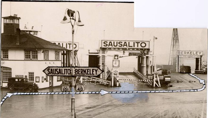
In 1909, the City built a municipal wharf at the foot of University Avenue which was used primarily for freight. Starting in 1926, the Golden Gate Ferry Company began construction of the Berkeley Pier. It was built out from the foot of University Avenue about 3.5 miles (5.6 kilometers) into the Bay (measured from the original shoreline). On June 16, 1927, auto ferry service began.[1] between the Berkeley Pier and the Hyde Street Pier in San Francisco, a pier shared with the Sausalito ferry.[2] During this period US Route 40 ran from San Pablo Avenue down University Avenue to the Berkeley Pier. The ferry service lasted until about 1937, after the 1936 opening of the San Francisco–Oakland Bay Bridge. Thereafter it became a fishing pier. US 40 was shifted to the new Eastshore Highway and the Bay Bridge. Storms damaged the end of the pier over the years and it was closed. After World War II ended, it was repaired and re-opened in 1946 for fishing.[3] In the 1970s, the city again repaired and upgraded the least damaged length of the Berkeley Pier, and it was in use until 2015 for fishing and viewing.
Since about the late 1920s, the city municipal dump was located here, and the accumulated garbage and construction debris accounts for most of the dry land of the Berkeley Marina. In the early 1990s much of the former dump was landscaped and converted into a park, originally named "North Waterfront Park". The park was renamed César Chávez Park in 1996 to commemorate the late California labor leader.[4]
The actual Berkeley Marina, used by many people who sail on the Bay, was constructed as the Berkeley Yacht Harbor in the late 1930s by the Works Progress Administration in conjunction with its nearby work developing Aquatic Park.
From October 1961 until April 5, 1974 a heliport was operated by San Francisco and Oakland Helicopter Airlines (known as SFO Helicopter Airlines) on the north side of University Avenue west of I-80 near the marina.[6] This helicopter airline transported passengers to the San Francisco (SFO) and Oakland (OAK) international airports,[7] and also at one point to downtown San Francisco.[8] SFO Helicopter operated jet turbine powered Sikorsky S-61 and Sikorsky S-62 helicopters into the heliport which is no longer in existence.
See alsoEdit
An AC Transit bus at its terminus of old route 9 at the Marina
Berkeley, California: the story of the evolution of a hamlet into a city of culture and commerce by William Warren Ferrier, Imprint Berkeley, Calif. (1933); pp. 375–6
Berkeley: The Town and the Gown of It, by George Pettitt, Howell-North Books, Berkeley (1973)
Berkeley: The First Seventy-Five Years, Federal Writers Project (1941), p. 140
berkeley, marina, westernmost, portion, city, berkeley, california, located, west, eastshore, freeway, interstate, foot, university, avenue, francisco, narrowly, speaking, refers, only, city, marina, common, usage, applies, more, generally, surrounding, area, . The Berkeley Marina is the westernmost portion of the city of Berkeley California located west of the Eastshore Freeway Interstate 80 and 580 at the foot of University Avenue on San Francisco Bay Narrowly speaking Berkeley Marina refers only to the city marina but in common usage it applies more generally to the surrounding area Berkeley MarinaNeighborhood of BerkeleyThe Berkeley Marina during sunsetBerkeley MarinaLocation within Berkeley and the East BayCoordinates 37 52 04 N 122 18 45 W 37 86767 N 122 3125 W 37 86767 122 3125CountryUnited StatesStateCaliforniaCountyAlamedaCityBerkeleyThere are several restaurants a hotel and a yacht club in the Berkeley Marina There are also several walking and bicycle paths The area is accessible from the rest of Berkeley by foot or bike over the Berkeley I 80 Bridge at the foot of Addison Street one block south of University Avenue and is traversed near Interstate 80 by a segment of the San Francisco Bay Trail In addition it is the western terminus of AC Transit Route 51B University Avenue Rockridge BART on select trips only The easternmost portion of the Marina running parallel to I 80 580 is now a part of the Eastshore State Park Contents 1 History 1 1 Berkeley heliport 2 See also 3 References 4 External linksHistory EditThe Berkeley Marina was originally part of the open waters of San Francisco Bay The original shoreline ran a few yards west of the Southern Pacific now Union Pacific tracks on Third Street The area was gradually filled in over the years nbsp Remnants of the original length of the Berkeley PierIn 1909 the City built a municipal wharf at the foot of University Avenue which was used primarily for freight Starting in 1926 the Golden Gate Ferry Company began construction of the Berkeley Pier It was built out from the foot of University Avenue about 3 5 miles 5 6 kilometers into the Bay measured from the original shoreline On June 16 1927 auto ferry service began 1 between the Berkeley Pier and the Hyde Street Pier in San Francisco a pier shared with the Sausalito ferry 2 During this period US Route 40 ran from San Pablo Avenue down University Avenue to the Berkeley Pier The ferry service lasted until about 1937 after the 1936 opening of the San Francisco Oakland Bay Bridge Thereafter it became a fishing pier US 40 was shifted to the new Eastshore Highway and the Bay Bridge Storms damaged the end of the pier over the years and it was closed After World War II ended it was repaired and re opened in 1946 for fishing 3 In the 1970s the city again repaired and upgraded the least damaged length of the Berkeley Pier and it was in use until 2015 for fishing and viewing Since about the late 1920s the city municipal dump was located here and the accumulated garbage and construction debris accounts for most of the dry land of the Berkeley Marina In the early 1990s much of the former dump was landscaped and converted into a park originally named North Waterfront Park The park was renamed Cesar Chavez Park in 1996 to commemorate the late California labor leader 4 The actual Berkeley Marina used by many people who sail on the Bay was constructed as the Berkeley Yacht Harbor in the late 1930s by the Works Progress Administration in conjunction with its nearby work developing Aquatic Park During World War II the Berkeley Yacht Harbor was used by the United States Navy to construct tug boats 5 Berkeley heliport Edit From October 1961 until April 5 1974 a heliport was operated by San Francisco and Oakland Helicopter Airlines known as SFO Helicopter Airlines on the north side of University Avenue west of I 80 near the marina 6 This helicopter airline transported passengers to the San Francisco SFO and Oakland OAK international airports 7 and also at one point to downtown San Francisco 8 SFO Helicopter operated jet turbine powered Sikorsky S 61 and Sikorsky S 62 helicopters into the heliport which is no longer in existence See also Edit nbsp An AC Transit bus at its terminus of old route 9 at the Marina nbsp San Francisco Bay Area portalBerkeley Pier Cesar Chavez Park OCSC Sailing Adventure Playground Berkeley References Edit Fourth Annual Report of the City Manager 1926 27 City of Berkeley p 16 http webbie1 sfpl org multimedia sfphotos AAC 2256 jpg bare URL image file City Council Minutes April 3 1946 Web Page Moved or not found City of Berkeley CA Berkeley Daily Gazette January 2 1942 p 11 Berkeley Gazette April 6 1974 Berkeley Historical Society Newsletter Summer 2006 p 5 http www timetableimages com Sept 1 1961 SFO Helicopter Airlines system timetable Berkeley California the story of the evolution of a hamlet into a city of culture and commerce by William Warren Ferrier Imprint Berkeley Calif 1933 pp 375 6 Berkeley The Town and the Gown of It by George Pettitt Howell North Books Berkeley 1973 Berkeley The First Seventy Five Years Federal Writers Project 1941 p 140External links EditCity of Berkeley Marina 37 52 04 N 122 18 45 W 37 86767 N 122 3125 W 37 86767 122 3125 Retrieved from https en wikipedia org w index php title Berkeley Marina amp oldid 1163147058, wikipedia, wiki, book, books, library,