fbpx
Wikipedia

Geology of Mercury

The geology of Mercury is the scientific study of the surface, crust, and interior of the planet Mercury. It emphasizes the composition, structure, history, and physical processes that shape the planet. It is analogous to the field of terrestrial geology. In planetary science, the term geology is used in its broadest sense to mean the study of the solid parts of planets and moons. The term incorporates aspects of geophysics, geochemistry, mineralogy, geodesy, and cartography.[1]

Caravaggio is an example of a Peak ring impact basin on Mercury.
Several areas on Mercury are extremely dark, such as a small crater within Hemingway crater in the lower right.

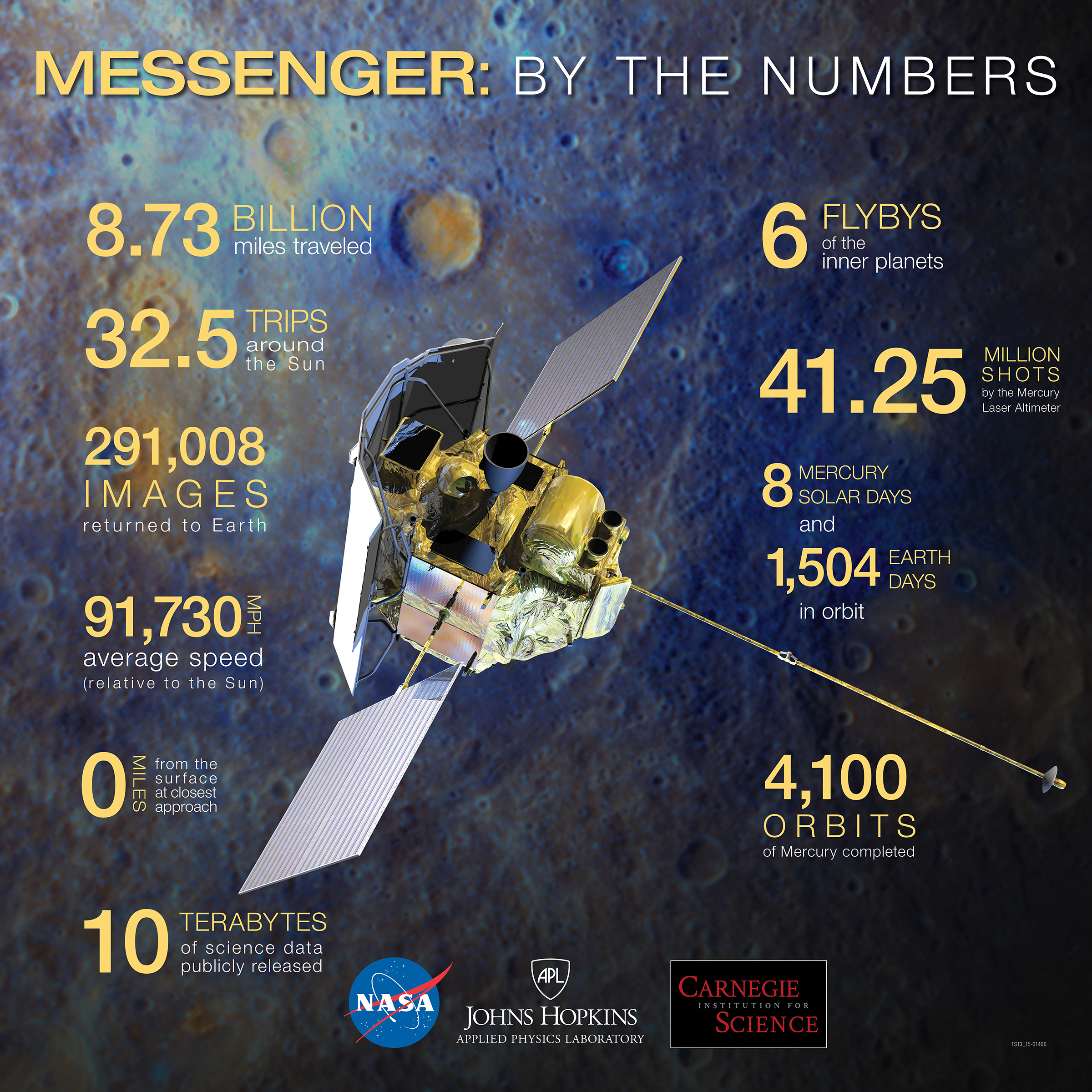
Historically, Mercury has been the least understood of all the terrestrial planets in the Solar System. This stems largely from its proximity to the Sun which makes reaching it with spacecraft technically challenging and Earth-based observations difficult. For decades, the principal source of geologic information about Mercury came from the 2,700 images taken by the Mariner 10 spacecraft during three flybys of the planet from 1974 to 1975. These images covered about 45% of the planet’s surface, but many of them were unsuitable for detailed geologic investigation because of high sun angles which made it hard to determine surface morphology and topography.[2] This dearth of information was greatly alleviated by the MErcury Surface, Space ENvironment, GEochemistry, and Ranging (MESSENGER) spacecraft which between 2008 and 2015 collected over 291,000 images [3] covering the entire planet, along with a wealth of other scientific data. The European Space Agency’s (ESA’s) BepiColumbo spacecraft, scheduled to go into orbit around Mercury in 2025, is expected to help answer many of the remaining questions about Mercury’s geology.

Mercury's surface is dominated by impact craters, basaltic rock and smooth plains, many of them a result of flood volcanism, similar in some respects to the lunar maria,[4][5] and locally by pyroclastic deposits.[6] Other notable features include vents which appear to be the source of magma-carved valleys, often-grouped irregular-shaped depressions termed "hollows" that are believed to be the result of collapsed magma chambers,[7] scarps indicative of thrust faulting, and mineral deposits (possibly ice) inside craters at the poles. Long thought to be geologically inactive, new evidence suggests there may still be some level of activity.[8][9]

Mercury's density implies a solid iron-rich core that accounts for about 60% of its volume (75% of its radius).[10] Mercury's magnetic equator is shifted nearly 20% of the planet's radius towards the north, the largest ratio of all planets.[11] This shift suggests there being one or more iron-rich molten layers surrounding the core producing a dynamo effect similar to that of Earth. Additionally, the offset magnetic dipole may result in uneven surface weathering by the solar wind, knocking more surface particles up into the southern exosphere and transporting them for deposit in the north. Scientists are gathering telemetry to determine if such is the case.[11]

After having completed the first solar day of its mission in September 2011, more than 99% of Mercury's surface had been mapped by NASA's MESSENGER probe in both color and monochrome with such detail that scientists' understanding of Mercury's geology has significantly surpassed the level achieved following the Mariner 10 flybys of the 1970s.[7]

Difficulties in exploration edit

 
Mariner 10 probe

Reaching Mercury from Earth poses significant technical challenges, because the planet orbits so much closer to the Sun than does the Earth. A Mercury-bound spacecraft launched from Earth must travel 91 million kilometers into the Sun's gravitational potential well.[12] Starting from the Earth's orbital speed of 30 km/s, the change in velocity (delta-v) the spacecraft must make to enter into a Hohmann transfer orbit that passes near Mercury is large compared to other planetary missions. The potential energy liberated by moving down the Sun's potential well becomes kinetic energy; requiring another large delta-v to do anything other than rapidly pass by Mercury. In order to land safely or enter a stable orbit the spacecraft must rely entirely on rocket motors because Mercury has negligible atmosphere. A direct trip to Mercury actually requires more rocket fuel than that required to escape the Solar System completely. As a result, only two space probes, Mariner 10 and MESSENGER, both by NASA, have visited Mercury so far.

 
Internal structure of Mercury

Furthermore, the space environment near Mercury is demanding, posing the double dangers to spacecraft of intense solar radiation and high temperatures.

Historically, a second obstacle has been that Mercury's period of rotation is a slow 58 Earth days,[13] so that spacecraft flybys are restricted to viewing only a single illuminated hemisphere. In fact, unfortunately, even though Mariner 10 space probe flew past Mercury three times during 1974 and 1975, it observed the same area during each pass. This was because Mariner 10's orbital period was almost exactly 3 sidereal Mercury days, and the same face of the planet was lit at each of the close approaches. As a result, less than 45% of the planet's surface was mapped.

Earth-based observations are made difficult by Mercury's constant proximity to the Sun. This has several consequences:

  1. Whenever the sky is dark enough for viewing through telescopes, Mercury is always already near the horizon, where viewing conditions are poor anyway due to atmospheric factors.
  2. The Hubble Space Telescope and other space observatories are usually prevented from pointing close to the Sun for safety reasons (Erroneously pointing such sensitive instruments at the Sun is likely to cause permanent damage).

Mercury's geological history edit

 
Mercury – Gravity Anomalies – mass concentrations (red) suggest subsurface structure and evolution.

Like the Earth, Moon and Mars, Mercury's geologic history is divided up into eras. From oldest to youngest, these are: the pre-Tolstojan, Tolstojan, Calorian, Mansurian, and Kuiperian. These ages are based on relative dating only.[14]

After the formation of Mercury along with the rest of the Solar System 4.6 billion years ago, heavy bombardment by asteroids and comets ensued. The last intense bombardment phase, the Late Heavy Bombardment came to an end about 3.8 billion years ago. Some regions or massifs, a prominent one being the one that formed the Caloris Basin, were filled by magma eruptions from within the planet. These created smooth intercrater plains similar to the maria found on the Moon. Later, as the planet cooled and contracted, its surface began to crack and form ridges; these surface cracks and ridges can be seen on top of other features, such as the craters and smoother plains—a clear indication that they are more recent. Mercury's period of volcanism ended when the planet's mantle had contracted enough to prevent further lava from breaking through to the surface. This probably occurred at some point during its first 700 or 800 million years of history.

Since then, the main surface processes have been intermittent impacts.

Timeline edit

Time unit: millions of years

Surface features edit

Mercury's surface is overall similar in appearance to that of the Moon, with extensive mare-like plains and heavily cratered terrains similar to the lunar highlands and made locally by accumulations of pyroclastic deposits.[6]

Topography
 
Map of Mercury's northern hemisphere by the MLA instrument on MESSENGER
lowest (purple) to 10 km (6.2 mi) highest (red).

Boulders edit

Mercury compared to the moon has a rarity of boulders, about ~30x less boulders are found on Mercury than the moon. One explanation for the rarity of boulders is that the lifespan of boulders on Mercury can be less than the life span of boulders on the moon which is around 100 million years.[15]

Boulders that have been found on Mercury as associated with fresh impact craters that are hundreds of meters in diameter or larger.[16]

Impact basins and craters edit

 
Mercury's Caloris Basin is one of the largest impact features in the Solar System

Craters on Mercury range in diameter from small bowl-shaped craters to multi-ringed impact basins hundreds of kilometers across. They appear in all states of degradation, from relatively fresh rayed-craters, to highly degraded crater remnants. Mercurian craters differ subtly from Lunar craters – the extent of their ejecta blankets is much smaller, which is a consequence of the 2.5 times stronger surface gravity on Mercury.[14]

 
MASCS spectrum scan of Mercury's surface by MESSENGER
 
The so-called "Weird Terrain" formed by the Caloris Basin impact at its antipodal point

The largest known crater is the enormous Caloris Basin, with a diameter of 1,550 km.[17] A basin of comparable size, tentatively named Skinakas Basin had been postulated from low resolution Earth-based observations of the non-Mariner-imaged hemisphere, but has not been observed in MESSENGER imagery of the corresponding terrain. The impact which created the Caloris Basin was so powerful that its effects are seen on a global scale. It caused lava eruptions and left a concentric ring over 2 km tall surrounding the impact crater. At the antipode of the Caloris Basin lies a large region of unusual, hilly and furrowed terrain, sometimes called "Weird Terrain". The favoured hypothesis for the origin of this geomorphologic unit is that shock waves generated during the impact traveled around the planet, and when they converged at the basin's antipode (180 degrees away) the high stresses were capable of fracturing the surface.[18] A much less favoured idea was that this terrain formed as a result of the convergence of ejecta at this basin's antipode. Furthermore, the formation of the Caloris Basin appears to have produced a shallow depression concentric around the basin, which was later filled by the smooth plains (see below).

Overall about 15 impact basins have been identified on the imaged part of Mercury. Other notable basins include the 400 km wide, multi-ring, Tolstoj Basin which has an ejecta blanket extending up to 500 km from its rim, and its floor has been filled by smooth plains materials. Beethoven Basin also has a similar-sized ejecta blanket and a 625 km diameter rim.[14]

As on the Moon, fresh craters on Mercury show prominent bright ray systems. These are made by ejected debris, which tend to be brighter while they remain relatively fresh because of a lesser amount of space weathering than the surrounding older terrain.

Pit-floor craters edit

Some impact craters on Mercury have non-circular, irregularly shaped depressions or pits on their floors. Such craters have been termed pit-floor craters, and MESSENGER team members have suggested that such pits formed by the collapse of subsurface magma chambers. If this suggestion is correct, the pits are evidence of volcanic processes at work on Mercury.[9] Pit craters are rimless, often irregularly shaped, and steep-sided, and they display no associated ejecta or lava flows but are typically distinctive in color. For example, the pits of Praxiteles have an orange hue.[19] Thought to be evidence of shallow magmatic activity, pit craters may have formed when subsurface magma drained elsewhere and left a roof area unsupported, leading to collapse and the formation of the pit. Major craters exhibiting these features include Beckett, Gibran, Lermontov, Picasso, and Navoi, among others.[20] It was suggested that these pits with associated brighter and redder deposits may be pyroclastic deposits caused by explosive volcanism.[6]

 
Interior of Abedin crater

Plains edit

There are two geologically distinct plains units on Mercury:[14][21]

  • Intercrater plains are the oldest visible surface,[14] predating the heavily cratered terrain. They are gently rolling or hilly and occur in the regions between larger craters. The intercrater plains appear to have obliterated many earlier craters, and show a general paucity of smaller craters below about 30 km in diameter.[21] It is not clear whether they are of volcanic or impact origin.[21] The intercrater plains are distributed roughly uniformly over the entire surface of the planet.
  • Smooth plains are widespread flat areas resembling the lunar maria, which fill depressions of various sizes. Notably, they fill a wide ring surrounding the Caloris Basin. An appreciable difference to the lunar maria is that the smooth plains of Mercury have the same albedo as the older intercrater plains. Despite a lack of unequivocally volcanic features, their localisation and lobate-shaped colour units strongly support a volcanic origin. All the Mercurian smooth plains formed significantly later than the Caloris basin, as evidenced by appreciably smaller crater densities than on the Caloris ejecta blanket.[14]

The floor of the Caloris Basin is also filled by a geologically distinct flat plain, broken up by ridges and fractures in a roughly polygonal pattern. It is not clear whether they are volcanic lavas induced by the impact, or a large sheet of impact melt.[14]

Tectonic features edit

 
Discovery Rupes.

One unusual feature of the planet's surface is the numerous compression folds which crisscross the plains. It is thought that as the planet's interior cooled, it contracted and its surface began to deform. The folds can be seen on top of other features, such as craters and smoother plains, indicating that they are more recent.[22] Mercury's surface is also flexed by significant tidal bulges raised by the Sun—the Sun's tides on Mercury are about 17% stronger than the Moon's on Earth.[23]

Faculae edit

Faculae on Mercury are bright areas often surrounding irregular depressions. They are generally interpreted to be pyroclastic in nature.[24] The faculae on Mercury are all named using words in different languages meaning snake.

Terminology edit

Non-crater surface features are given the following names:

High-albedo polar patches and possible presence of ice edit

The first radar observations of Mercury were carried out by the radiotelescopes at Arecibo (Puerto Rico) and Goldstone (California, United States), with assistance from the U.S. National Radio Astronomy Observatory Very Large Array (VLA) facility in New Mexico. The transmissions sent from the NASA Deep Space Network site at Goldstone were at a power level of 460 kW at 8.51 GHz; the signals received by the VLA multi-dish array detected points of radar reflectivity (radar luminosity) with depolarized waves from Mercury's north pole.

 
Radar image of Mercury's north pole.

Radar maps of the surface of the planet were made using the Arecibo radiotelescope. The survey was conducted with 420 kW UHF band (2.4 GHz) radio waves which allowed for a 15 km resolution. This study not only confirmed the existence of the zones of high reflectivity and depolarization, but also found a number of new areas (bringing the total to 20) and was even able to survey the poles. It has been postulated that surface ice may be responsible for these high luminosity levels, as the silicate rocks that compose most of the surface of Mercury have exactly the opposite effect on luminosity.

In spite of its proximity to the Sun, Mercury may have surface ice, since temperatures near the poles are constantly below freezing point: On the polar plains, the temperature does not rise above −106 °C. Craters at Mercury's higher latitudes (discovered by radar surveys from Earth as well) may be deep enough to shield the ice from direct sunlight. Inside the craters, where there is no solar light, temperatures fall to −171 °C.[25]

Despite sublimation into the vacuum of space, the temperature in the permanently shadowed region is so low that this sublimation is slow enough to potentially preserve deposited ice for billions of years.

At the South Pole, the location of a large zone of high reflectivity coincides with the location of the Chao Meng-Fu crater, and other small craters containing reflective areas have also been identified. At the North Pole, a number of craters smaller than Chao-Meng Fu have these reflective properties.

The strength of the radar reflections seen on Mercury are small compared to that which would occur with pure ice. This may be due to powder deposition that does not cover the surface of the crater completely or other causes, e.g. a thin overlying surface layer. However, the evidence for ice on Mercury is not definitive. The anomalous reflective properties could also be due to the existence of deposits of metallic sulfates or other materials with high reflectance.

Possible origin of ice edit

Mercury is not unique in having craters that stand in permanent shadow; at the south pole of Earth's Moon there is a large crater (Aitken) where some possible signs of the presence of ice have been seen (although their interpretation is disputed). It is thought by astronomers that ice on both Mercury and the Moon must have originated from external sources, mostly impacting comets. These are known to contain large amounts, or a majority, of ice. It is therefore conceivable for meteorite impacts to have deposited water in the permanently shadow craters, where it would remain unwarmed for possibly billions of years due to the lack of an atmosphere to efficiently conduct heat and stable orientation of Mercury's rotation axis.

Mercury
 
Water ice (yellow) at Mercury's north polar region

Mercury's biological history edit

Habitability edit

There may be scientific support, based on studies reported in March 2020, for considering that parts of the planet Mercury may have been habitable, and perhaps that life forms, albeit likely primitive microorganisms, may have existed on the planet.[26][27]

See also edit

References edit

  1. ^ Greeley, Ronald (1993). Planetary landscapes (2nd ed.). New York: Chapman & Hall. p. 1. ISBN 0-412-05181-8.
  2. ^ Strom, R.G. in “Geology of the Terrestrial Planets,” M.H. Carr, Ed., Special Paper 469, NASA Scientific and Technical Information Branch:Washington D.C., 1984, p. 13. https://www.lpi.usra.edu/publications/books/geologyTerraPlanets/
  3. ^ MESSENGER website. Johns Hopkins Applied Physics Laboratory. https://messenger.jhuapl.edu/Explore/images/impressions/messenger-byTheNumbers-lg.jpg
  4. ^ . NASA. Archived from the original on 21 July 2011. Retrieved 17 February 2012.
  5. ^ . NASA. Archived from the original on 16 October 2011. Retrieved 16 February 2012.
  6. ^ a b c Thomas, Rebecca J.; Rothery, David A.; Conway, Susan J.; Anand, Mahesh (16 September 2014). "Long-lived explosive volcanism on Mercury". Geophysical Research Letters. 41 (17): 6084–6092. Bibcode:2014GeoRL..41.6084T. doi:10.1002/2014GL061224.
  7. ^ a b . Johns Hopkins University Applied Physics Lab. Archived from the original on 26 June 2015. Retrieved 16 February 2012.
  8. ^ "The MESSENGER Gamma-Ray Spectrometer: A window into the formation and early evolution of Mercury". Johns Hopkins University Applied Physics Lab. Archived from the original on 12 December 2012. Retrieved 18 February 2012.
  9. ^ a b . Johns Hopkins University Applied Physics Lab. Archived from the original on 28 April 2014. Retrieved 16 February 2012.
  10. ^ . Johns Hopkins University Applied Physics Lab. Archived from the original on 4 September 2014. Retrieved 18 February 2012.
  11. ^ a b "Mercury's Oddly Offset Magnetic Field". Johns Hopkins University Applied Physics Lab. Archived from the original on 12 December 2012. Retrieved 18 February 2012.
  12. ^ "Topic: 1.2.c Mercury missions | CosmoLearning Astronomy". CosmoLearning. Retrieved 24 July 2023.
  13. ^ "Mercury Fact Sheet". nssdc.gsfc.nasa.gov. Retrieved 24 July 2023.
  14. ^ a b c d e f g P. D. Spudis (2001). "The Geological History of Mercury". Workshop on Mercury: Space Environment, Surface, and Interior, Chicago (1097): 100. Bibcode:2001mses.conf..100S.
  15. ^ Kreslavsky, Mikhail A.; Zharkova, Anastasia; Gritsevich, Maria (1 September 2020). "Rarity of Boulders on Mercury: Possible Causes". European Planetary Science Congress: EPSC2020–958. Bibcode:2020EPSC...14..958K. doi:10.5194/epsc2020-958.
  16. ^ Kreslavsky, Mikhail A.; Zharkova, Anastasia Yu; Head, James W.; Gritsevich, Maria I. (November 2021). "Boulders on Mercury". Icarus. 369: 114628. arXiv:2108.01528. Bibcode:2021Icar..36914628K. doi:10.1016/j.icarus.2021.114628.
  17. ^ Shiga, David (30 January 2008). "Bizarre spider scar found on Mercury's surface". NewScientist.com news service.
  18. ^ Schultz, Peter H.; Gault, Donald E. (1975). "Seismic effects from major basin formations on the moon and mercury". The Moon. 12 (2): 159–177. Bibcode:1975Moon...12..159S. doi:10.1007/BF00577875. S2CID 121225801.
  19. ^ . Johns Hopkins University Applied Physics Lab. Archived from the original on 26 June 2015. Retrieved 16 February 2012.
  20. ^ . Johns Hopkins University Applied Physics Lab. Archived from the original on 26 June 2015. Retrieved 16 February 2012.
  21. ^ a b c R.J. Wagner; et al. (2001). "Application of an Updated Impact Cratering Chronology Model to Mercury's Time-Stratigraphic System". Workshop on Mercury: Space Environment, Surface, and Interior, Chicago (1097): 106. Bibcode:2001mses.conf..106W.
  22. ^ Dzurisin, D. (1978). "The tectonic and volcanic history of mercury as inferred from studies of scarps, ridges, troughs, and other lineaments". Journal of Geophysical Research: Solid Earth. 83 (B10): 4883–4906. Bibcode:1978JGR....83.4883D. doi:10.1029/JB083iB10p04883.
  23. ^ Van Hoolst, T.; Jacobs, C. (2003). "Mercury's tides and interior structure". Journal of Geophysical Research: Planets. 108 (E11): 5121. Bibcode:2003JGRE..108.5121V. doi:10.1029/2003JE002126.
  24. ^ Pyroclastic Deposits on Mercury Detected With MASCS/Messenger Data: Identification Through Spectral Characterization and Principal Component Analysis(PCA). By A. Galiano, F. Capaccioni, G. Filacchione, C. Carli. 53rd Lunar and Planetary Science Conference (2022).
  25. ^ "Ice on Mercury". National Space Science Data Center. Retrieved 16 February 2012.
  26. ^ Hall, Shannon (24 March 2020). "Life on the Planet Mercury? 'It's Not Completely Nuts' - A new explanation for the rocky world's jumbled landscape opens a possibility that it could have had ingredients for habitability". The New York Times. Retrieved 26 March 2020.
  27. ^ Roddriquez, J. Alexis P.; et al. (16 March 2020). "The Chaotic Terrains of Mercury Reveal a History of Planetary Volatile Retention and Loss in the Innermost Solar System". Scientific Reports. 10 (4737): 4737. Bibcode:2020NatSR..10.4737R. doi:10.1038/s41598-020-59885-5. PMC 7075900. PMID 32179758.
  • Stardate, Guide to the Solar System. Publicación de la University of Texas at Austin McDonald Observatory
  • Our Solar System, A Geologic Snapshot. NASA (NP-157). May 1992.
  • Fotografía: Mercury. NASA (LG-1997-12478-HQ)
  • This article draws heavily on the corresponding article in the Spanish-language Wikipedia, which was accessed in the version of 26 June 2005.

Original references for Spanish article edit

  • Ciencias de la Tierra. Una Introducción a la Geología Física (Earth Sciences, an Introduction to Physical Geology), by Edward J. Tarbuck y Frederick K. Lutgens. Prentice Hall (1999).
  • "Hielo en Mercurio" ("Ice on Mercury"). El Universo, Enciclopedia de la Astronomía y el Espacio ("The Universe, Encyclopedia of Astronomy and the Space"), Editorial Planeta-De Agostini, p. 141–145. Volume 5. (1997)

External links edit

  • MESSENGER probe
  • Mercury on Nineplanets.org
  • USGS Geology of Mercury Retrieved 5 August 2007

geology, mercury, this, article, includes, list, references, related, reading, external, links, sources, remain, unclear, because, lacks, inline, citations, please, help, improve, this, article, introducing, more, precise, citations, november, 2021, learn, whe. This article includes a list of references related reading or external links but its sources remain unclear because it lacks inline citations Please help improve this article by introducing more precise citations November 2021 Learn how and when to remove this message The geology of Mercury is the scientific study of the surface crust and interior of the planet Mercury It emphasizes the composition structure history and physical processes that shape the planet It is analogous to the field of terrestrial geology In planetary science the term geology is used in its broadest sense to mean the study of the solid parts of planets and moons The term incorporates aspects of geophysics geochemistry mineralogy geodesy and cartography 1 Caravaggio is an example of a Peak ring impact basin on Mercury Several areas on Mercury are extremely dark such as a small crater within Hemingway crater in the lower right Historically Mercury has been the least understood of all the terrestrial planets in the Solar System This stems largely from its proximity to the Sun which makes reaching it with spacecraft technically challenging and Earth based observations difficult For decades the principal source of geologic information about Mercury came from the 2 700 images taken by the Mariner 10 spacecraft during three flybys of the planet from 1974 to 1975 These images covered about 45 of the planet s surface but many of them were unsuitable for detailed geologic investigation because of high sun angles which made it hard to determine surface morphology and topography 2 This dearth of information was greatly alleviated by the MErcury Surface Space ENvironment GEochemistry and Ranging MESSENGER spacecraft which between 2008 and 2015 collected over 291 000 images 3 covering the entire planet along with a wealth of other scientific data The European Space Agency s ESA s BepiColumbo spacecraft scheduled to go into orbit around Mercury in 2025 is expected to help answer many of the remaining questions about Mercury s geology Mercury s surface is dominated by impact craters basaltic rock and smooth plains many of them a result of flood volcanism similar in some respects to the lunar maria 4 5 and locally by pyroclastic deposits 6 Other notable features include vents which appear to be the source of magma carved valleys often grouped irregular shaped depressions termed hollows that are believed to be the result of collapsed magma chambers 7 scarps indicative of thrust faulting and mineral deposits possibly ice inside craters at the poles Long thought to be geologically inactive new evidence suggests there may still be some level of activity 8 9 Mercury s density implies a solid iron rich core that accounts for about 60 of its volume 75 of its radius 10 Mercury s magnetic equator is shifted nearly 20 of the planet s radius towards the north the largest ratio of all planets 11 This shift suggests there being one or more iron rich molten layers surrounding the core producing a dynamo effect similar to that of Earth Additionally the offset magnetic dipole may result in uneven surface weathering by the solar wind knocking more surface particles up into the southern exosphere and transporting them for deposit in the north Scientists are gathering telemetry to determine if such is the case 11 After having completed the first solar day of its mission in September 2011 more than 99 of Mercury s surface had been mapped by NASA s MESSENGER probe in both color and monochrome with such detail that scientists understanding of Mercury s geology has significantly surpassed the level achieved following the Mariner 10 flybys of the 1970s 7 Contents 1 Difficulties in exploration 2 Mercury s geological history 2 1 Timeline 3 Surface features 3 1 Boulders 3 2 Impact basins and craters 3 2 1 Pit floor craters 3 3 Plains 3 4 Tectonic features 3 5 Faculae 3 6 Terminology 4 High albedo polar patches and possible presence of ice 4 1 Possible origin of ice 5 Mercury s biological history 5 1 Habitability 6 See also 7 References 7 1 Original references for Spanish article 8 External linksDifficulties in exploration edit nbsp Mariner 10 probe Reaching Mercury from Earth poses significant technical challenges because the planet orbits so much closer to the Sun than does the Earth A Mercury bound spacecraft launched from Earth must travel 91 million kilometers into the Sun s gravitational potential well 12 Starting from the Earth s orbital speed of 30 km s the change in velocity delta v the spacecraft must make to enter into a Hohmann transfer orbit that passes near Mercury is large compared to other planetary missions The potential energy liberated by moving down the Sun s potential well becomes kinetic energy requiring another large delta v to do anything other than rapidly pass by Mercury In order to land safely or enter a stable orbit the spacecraft must rely entirely on rocket motors because Mercury has negligible atmosphere A direct trip to Mercury actually requires more rocket fuel than that required to escape the Solar System completely As a result only two space probes Mariner 10 and MESSENGER both by NASA have visited Mercury so far nbsp Internal structure of Mercury Furthermore the space environment near Mercury is demanding posing the double dangers to spacecraft of intense solar radiation and high temperatures Historically a second obstacle has been that Mercury s period of rotation is a slow 58 Earth days 13 so that spacecraft flybys are restricted to viewing only a single illuminated hemisphere In fact unfortunately even though Mariner 10 space probe flew past Mercury three times during 1974 and 1975 it observed the same area during each pass This was because Mariner 10 s orbital period was almost exactly 3 sidereal Mercury days and the same face of the planet was lit at each of the close approaches As a result less than 45 of the planet s surface was mapped Earth based observations are made difficult by Mercury s constant proximity to the Sun This has several consequences Whenever the sky is dark enough for viewing through telescopes Mercury is always already near the horizon where viewing conditions are poor anyway due to atmospheric factors The Hubble Space Telescope and other space observatories are usually prevented from pointing close to the Sun for safety reasons Erroneously pointing such sensitive instruments at the Sun is likely to cause permanent damage Mercury s geological history edit nbsp Mercury Gravity Anomalies mass concentrations red suggest subsurface structure and evolution Like the Earth Moon and Mars Mercury s geologic history is divided up into eras From oldest to youngest these are the pre Tolstojan Tolstojan Calorian Mansurian and Kuiperian These ages are based on relative dating only 14 After the formation of Mercury along with the rest of the Solar System 4 6 billion years ago heavy bombardment by asteroids and comets ensued The last intense bombardment phase the Late Heavy Bombardment came to an end about 3 8 billion years ago Some regions or massifs a prominent one being the one that formed the Caloris Basin were filled by magma eruptions from within the planet These created smooth intercrater plains similar to the maria found on the Moon Later as the planet cooled and contracted its surface began to crack and form ridges these surface cracks and ridges can be seen on top of other features such as the craters and smoother plains a clear indication that they are more recent Mercury s period of volcanism ended when the planet s mantle had contracted enough to prevent further lava from breaking through to the surface This probably occurred at some point during its first 700 or 800 million years of history Since then the main surface processes have been intermittent impacts Timeline edit Time unit millions of yearsSurface features editMercury s surface is overall similar in appearance to that of the Moon with extensive mare like plains and heavily cratered terrains similar to the lunar highlands and made locally by accumulations of pyroclastic deposits 6 Topography nbsp Map of Mercury s northern hemisphere by the MLA instrument on MESSENGERlowest purple to 10 km 6 2 mi highest red Boulders edit Mercury compared to the moon has a rarity of boulders about 30x less boulders are found on Mercury than the moon One explanation for the rarity of boulders is that the lifespan of boulders on Mercury can be less than the life span of boulders on the moon which is around 100 million years 15 Boulders that have been found on Mercury as associated with fresh impact craters that are hundreds of meters in diameter or larger 16 Impact basins and craters edit Main article Craters on Mercury nbsp Mercury s Caloris Basin is one of the largest impact features in the Solar System Craters on Mercury range in diameter from small bowl shaped craters to multi ringed impact basins hundreds of kilometers across They appear in all states of degradation from relatively fresh rayed craters to highly degraded crater remnants Mercurian craters differ subtly from Lunar craters the extent of their ejecta blankets is much smaller which is a consequence of the 2 5 times stronger surface gravity on Mercury 14 nbsp MASCS spectrum scan of Mercury s surface by MESSENGER nbsp The so called Weird Terrain formed by the Caloris Basin impact at its antipodal point The largest known crater is the enormous Caloris Basin with a diameter of 1 550 km 17 A basin of comparable size tentatively named Skinakas Basin had been postulated from low resolution Earth based observations of the non Mariner imaged hemisphere but has not been observed in MESSENGER imagery of the corresponding terrain The impact which created the Caloris Basin was so powerful that its effects are seen on a global scale It caused lava eruptions and left a concentric ring over 2 km tall surrounding the impact crater At the antipode of the Caloris Basin lies a large region of unusual hilly and furrowed terrain sometimes called Weird Terrain The favoured hypothesis for the origin of this geomorphologic unit is that shock waves generated during the impact traveled around the planet and when they converged at the basin s antipode 180 degrees away the high stresses were capable of fracturing the surface 18 A much less favoured idea was that this terrain formed as a result of the convergence of ejecta at this basin s antipode Furthermore the formation of the Caloris Basin appears to have produced a shallow depression concentric around the basin which was later filled by the smooth plains see below Overall about 15 impact basins have been identified on the imaged part of Mercury Other notable basins include the 400 km wide multi ring Tolstoj Basin which has an ejecta blanket extending up to 500 km from its rim and its floor has been filled by smooth plains materials Beethoven Basin also has a similar sized ejecta blanket and a 625 km diameter rim 14 As on the Moon fresh craters on Mercury show prominent bright ray systems These are made by ejected debris which tend to be brighter while they remain relatively fresh because of a lesser amount of space weathering than the surrounding older terrain Pit floor craters edit Some impact craters on Mercury have non circular irregularly shaped depressions or pits on their floors Such craters have been termed pit floor craters and MESSENGER team members have suggested that such pits formed by the collapse of subsurface magma chambers If this suggestion is correct the pits are evidence of volcanic processes at work on Mercury 9 Pit craters are rimless often irregularly shaped and steep sided and they display no associated ejecta or lava flows but are typically distinctive in color For example the pits of Praxiteles have an orange hue 19 Thought to be evidence of shallow magmatic activity pit craters may have formed when subsurface magma drained elsewhere and left a roof area unsupported leading to collapse and the formation of the pit Major craters exhibiting these features include Beckett Gibran Lermontov Picasso and Navoi among others 20 It was suggested that these pits with associated brighter and redder deposits may be pyroclastic deposits caused by explosive volcanism 6 nbsp Interior of Abedin crater Plains edit There are two geologically distinct plains units on Mercury 14 21 Intercrater plains are the oldest visible surface 14 predating the heavily cratered terrain They are gently rolling or hilly and occur in the regions between larger craters The intercrater plains appear to have obliterated many earlier craters and show a general paucity of smaller craters below about 30 km in diameter 21 It is not clear whether they are of volcanic or impact origin 21 The intercrater plains are distributed roughly uniformly over the entire surface of the planet Smooth plains are widespread flat areas resembling the lunar maria which fill depressions of various sizes Notably they fill a wide ring surrounding the Caloris Basin An appreciable difference to the lunar maria is that the smooth plains of Mercury have the same albedo as the older intercrater plains Despite a lack of unequivocally volcanic features their localisation and lobate shaped colour units strongly support a volcanic origin All the Mercurian smooth plains formed significantly later than the Caloris basin as evidenced by appreciably smaller crater densities than on the Caloris ejecta blanket 14 The floor of the Caloris Basin is also filled by a geologically distinct flat plain broken up by ridges and fractures in a roughly polygonal pattern It is not clear whether they are volcanic lavas induced by the impact or a large sheet of impact melt 14 Tectonic features edit nbsp Discovery Rupes One unusual feature of the planet s surface is the numerous compression folds which crisscross the plains It is thought that as the planet s interior cooled it contracted and its surface began to deform The folds can be seen on top of other features such as craters and smoother plains indicating that they are more recent 22 Mercury s surface is also flexed by significant tidal bulges raised by the Sun the Sun s tides on Mercury are about 17 stronger than the Moon s on Earth 23 Faculae edit Faculae on Mercury are bright areas often surrounding irregular depressions They are generally interpreted to be pyroclastic in nature 24 The faculae on Mercury are all named using words in different languages meaning snake Terminology edit Non crater surface features are given the following names Albedo features areas of markedly different reflectivity Dorsa ridges see List of ridges on Mercury Montes mountains see List of mountains on Mercury Planitiae plains see List of plains on Mercury Rupes scarps see List of scarps on Mercury Valles valleys see List of valleys on Mercury High albedo polar patches and possible presence of ice editThe first radar observations of Mercury were carried out by the radiotelescopes at Arecibo Puerto Rico and Goldstone California United States with assistance from the U S National Radio Astronomy Observatory Very Large Array VLA facility in New Mexico The transmissions sent from the NASA Deep Space Network site at Goldstone were at a power level of 460 kW at 8 51 GHz the signals received by the VLA multi dish array detected points of radar reflectivity radar luminosity with depolarized waves from Mercury s north pole nbsp Radar image of Mercury s north pole Radar maps of the surface of the planet were made using the Arecibo radiotelescope The survey was conducted with 420 kW UHF band 2 4 GHz radio waves which allowed for a 15 km resolution This study not only confirmed the existence of the zones of high reflectivity and depolarization but also found a number of new areas bringing the total to 20 and was even able to survey the poles It has been postulated that surface ice may be responsible for these high luminosity levels as the silicate rocks that compose most of the surface of Mercury have exactly the opposite effect on luminosity In spite of its proximity to the Sun Mercury may have surface ice since temperatures near the poles are constantly below freezing point On the polar plains the temperature does not rise above 106 C Craters at Mercury s higher latitudes discovered by radar surveys from Earth as well may be deep enough to shield the ice from direct sunlight Inside the craters where there is no solar light temperatures fall to 171 C 25 Despite sublimation into the vacuum of space the temperature in the permanently shadowed region is so low that this sublimation is slow enough to potentially preserve deposited ice for billions of years At the South Pole the location of a large zone of high reflectivity coincides with the location of the Chao Meng Fu crater and other small craters containing reflective areas have also been identified At the North Pole a number of craters smaller than Chao Meng Fu have these reflective properties The strength of the radar reflections seen on Mercury are small compared to that which would occur with pure ice This may be due to powder deposition that does not cover the surface of the crater completely or other causes e g a thin overlying surface layer However the evidence for ice on Mercury is not definitive The anomalous reflective properties could also be due to the existence of deposits of metallic sulfates or other materials with high reflectance Possible origin of ice edit Mercury is not unique in having craters that stand in permanent shadow at the south pole of Earth s Moon there is a large crater Aitken where some possible signs of the presence of ice have been seen although their interpretation is disputed It is thought by astronomers that ice on both Mercury and the Moon must have originated from external sources mostly impacting comets These are known to contain large amounts or a majority of ice It is therefore conceivable for meteorite impacts to have deposited water in the permanently shadow craters where it would remain unwarmed for possibly billions of years due to the lack of an atmosphere to efficiently conduct heat and stable orientation of Mercury s rotation axis Mercury nbsp Water ice yellow at Mercury s north polar regionMercury s biological history editHabitability edit There may be scientific support based on studies reported in March 2020 for considering that parts of the planet Mercury may have been habitable and perhaps that life forms albeit likely primitive microorganisms may have existed on the planet 26 27 See also editAtmosphere of Mercury Composition and properties of the atmosphere of the innermost planet of the Solar System List of craters on Mercury List of geological features on MercuryReferences edit Greeley Ronald 1993 Planetary landscapes 2nd ed New York Chapman amp Hall p 1 ISBN 0 412 05181 8 Strom R G in Geology of the Terrestrial Planets M H Carr Ed Special Paper 469 NASA Scientific and Technical Information Branch Washington D C 1984 p 13 https www lpi usra edu publications books geologyTerraPlanets MESSENGER website Johns Hopkins Applied Physics Laboratory https messenger jhuapl edu Explore images impressions messenger byTheNumbers lg jpg Solar System Exploration Mercury NASA Archived from the original on 21 July 2011 Retrieved 17 February 2012 MESSENGER Team Presents New Mercury Findings NASA Archived from the original on 16 October 2011 Retrieved 16 February 2012 a b c Thomas Rebecca J Rothery David A Conway Susan J Anand Mahesh 16 September 2014 Long lived explosive volcanism on Mercury Geophysical Research Letters 41 17 6084 6092 Bibcode 2014GeoRL 41 6084T doi 10 1002 2014GL061224 a b Orbital Observations of Mercury Johns Hopkins University Applied Physics Lab Archived from the original on 26 June 2015 Retrieved 16 February 2012 The MESSENGER Gamma Ray Spectrometer A window into the formation and early evolution of Mercury Johns Hopkins University Applied Physics Lab Archived from the original on 12 December 2012 Retrieved 18 February 2012 a b Evidence of Volcanism on Mercury It s the Pits Johns Hopkins University Applied Physics Lab Archived from the original on 28 April 2014 Retrieved 16 February 2012 Mercury The Key to Terrestrial Planet Evolution Johns Hopkins University Applied Physics Lab Archived from the original on 4 September 2014 Retrieved 18 February 2012 a b Mercury s Oddly Offset Magnetic Field Johns Hopkins University Applied Physics Lab Archived from the original on 12 December 2012 Retrieved 18 February 2012 Topic 1 2 c Mercury missions CosmoLearning Astronomy CosmoLearning Retrieved 24 July 2023 Mercury Fact Sheet nssdc gsfc nasa gov Retrieved 24 July 2023 a b c d e f g P D Spudis 2001 The Geological History of Mercury Workshop on Mercury Space Environment Surface and Interior Chicago 1097 100 Bibcode 2001mses conf 100S Kreslavsky Mikhail A Zharkova Anastasia Gritsevich Maria 1 September 2020 Rarity of Boulders on Mercury Possible Causes European Planetary Science Congress EPSC2020 958 Bibcode 2020EPSC 14 958K doi 10 5194 epsc2020 958 Kreslavsky Mikhail A Zharkova Anastasia Yu Head James W Gritsevich Maria I November 2021 Boulders on Mercury Icarus 369 114628 arXiv 2108 01528 Bibcode 2021Icar 36914628K doi 10 1016 j icarus 2021 114628 Shiga David 30 January 2008 Bizarre spider scar found on Mercury s surface NewScientist com news service Schultz Peter H Gault Donald E 1975 Seismic effects from major basin formations on the moon and mercury The Moon 12 2 159 177 Bibcode 1975Moon 12 159S doi 10 1007 BF00577875 S2CID 121225801 Overlaying Color onto Praxiteles Crater Johns Hopkins University Applied Physics Lab Archived from the original on 26 June 2015 Retrieved 16 February 2012 A Newly Pictured Pit Floor Crater Johns Hopkins University Applied Physics Lab Archived from the original on 26 June 2015 Retrieved 16 February 2012 a b c R J Wagner et al 2001 Application of an Updated Impact Cratering Chronology Model to Mercury s Time Stratigraphic System Workshop on Mercury Space Environment Surface and Interior Chicago 1097 106 Bibcode 2001mses conf 106W Dzurisin D 1978 The tectonic and volcanic history of mercury as inferred from studies of scarps ridges troughs and other lineaments Journal of Geophysical Research Solid Earth 83 B10 4883 4906 Bibcode 1978JGR 83 4883D doi 10 1029 JB083iB10p04883 Van Hoolst T Jacobs C 2003 Mercury s tides and interior structure Journal of Geophysical Research Planets 108 E11 5121 Bibcode 2003JGRE 108 5121V doi 10 1029 2003JE002126 Pyroclastic Deposits on Mercury Detected With MASCS Messenger Data Identification Through Spectral Characterization and Principal Component Analysis PCA By A Galiano F Capaccioni G Filacchione C Carli 53rd Lunar and Planetary Science Conference 2022 Ice on Mercury National Space Science Data Center Retrieved 16 February 2012 Hall Shannon 24 March 2020 Life on the Planet Mercury It s Not Completely Nuts A new explanation for the rocky world s jumbled landscape opens a possibility that it could have had ingredients for habitability The New York Times Retrieved 26 March 2020 Roddriquez J Alexis P et al 16 March 2020 The Chaotic Terrains of Mercury Reveal a History of Planetary Volatile Retention and Loss in the Innermost Solar System Scientific Reports 10 4737 4737 Bibcode 2020NatSR 10 4737R doi 10 1038 s41598 020 59885 5 PMC 7075900 PMID 32179758 Stardate Guide to the Solar System Publicacion de la University of Texas at Austin McDonald Observatory Our Solar System A Geologic Snapshot NASA NP 157 May 1992 Fotografia Mercury NASA LG 1997 12478 HQ This article draws heavily on the corresponding article in the Spanish language Wikipedia which was accessed in the version of 26 June 2005 Original references for Spanish article edit Ciencias de la Tierra Una Introduccion a la Geologia Fisica Earth Sciences an Introduction to Physical Geology by Edward J Tarbuck y Frederick K Lutgens Prentice Hall 1999 Hielo en Mercurio Ice on Mercury El Universo Enciclopedia de la Astronomia y el Espacio The Universe Encyclopedia of Astronomy and the Space Editorial Planeta De Agostini p 141 145 Volume 5 1997 External links editMariner 10 MESSENGER probe Mercury on Nineplanets org USGS Geology of Mercury Retrieved 5 August 2007 Retrieved from https en wikipedia org w index php title Geology of Mercury amp oldid 1223899901 High albedo polar patches and possible presence of ice, wikipedia, wiki, book, books, library,

article

, read, download, free, free download, mp3, video, mp4, 3gp, jpg, jpeg, gif, png, picture, music, song, movie, book, game, games.